Houghton-Le-Spring geodata
Houghton-Le-Spring (England) is a populated place; located in United Kingdom in Europe/London (GMT+1) time zone. With population of 37,840 people, there are 318 cities with bigger population in this country. Compared to other cities in United Kingdom, 85.3% of cities are located further ↓South; 56.2% of cities are located further ←West and 61.6% of cities have lower elevation than Houghton-Le-Spring. Note1


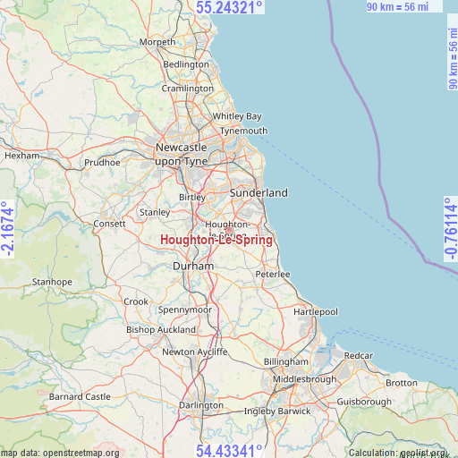
Houghton-Le-Spring GPS coordinates[2]
54° 50' 25.224" North, 1° 27' 51.372" West
| Map corner | latitude | longitude |
|---|---|---|
| Upper-left | 55.24321°, | -2.1674° |
| Center: | 54.84034°, | -1.46427° |
| Lower-right: | 54.43341°, | -0.76114° |
| Map W x H: | 90×90 km | = 55.9×55.9mi |
| max Lat: | 60.39635° ⇑14.7% North |
| Houghton-Le-Spring: | 54.84034° |
| min Lat: | ⇓85.3% South 34.60088° |
| min Long | Houghton-Le-Spr | max Long |
| -7.64133° | -1.46427° | 32.95536° |
| W 56.2%⇐ | ⇒43.8% E |
Elevation
Elevation of Houghton-Le-Spring is 79 m = 259 ft, and this is 6.1 m = 20 ft above average elevation for this country.
| Max E: |
515 m = 1690 ft | 38.4% |
| Houghton-Le-Spring | 79 m 259 ft | |
| Avg. | 72.9 m = 239 ft | |
Min E: |
-30 m = -98 ft | 61.6% |
See also: United Kingdom elevation on elevation.city.
Geographical zone
Houghton-Le-Spring is located in North temperate zone (between Tropic of Cancer and the Arctic Circle). Distance of this North polar circle is 1303.5 km =810 mi to North.| Distance of | km | miles | from Houghton-Le-Spring |
|---|---|---|---|
| North Pole | 3909.4 | 2429.2 | to North |
| Arctic Circle | 1303.5 | 810 | to North |
| Tropic Cancer | 3491.8 | 2169.7 | to South |
| Equator | 6097.7 | 3788.9 | to South |


Nearby cities:
15 places around Houghton-Le-Spring: (largest is in red/bold)
• Chester-le-Street
7.3 km =4.5 mi,  286°
286°
• East Rainton
2 km =1.2 mi,  211°
211°
• Haswell
7 km =4.3 mi,  154°
154°
• Hawthorn
8.6 km =5.3 mi,  121°
121°
• Hetton-Le-Hole
2.8 km =1.7 mi,  160°
160°
• Murton
5.3 km =3.3 mi, 117°
• Pittington
4.6 km =2.9 mi,  195°
195°
• Ryhope
7 km =4.3 mi,  60°
60°
• Seaham
7.6 km =4.7 mi,  91°
91°
• Sherburn
7.6 km =4.7 mi, 199°
• Sherburn Hill
7.6 km =4.7 mi,  187°
187°
• South Hetton
5.9 km =3.7 mi,  141°
141°
• Sunderland
8.9 km =5.5 mi,  36°
36°
• Washington
7.4 km =4.6 mi,  333°
333°
• West Rainton
3.5 km =2.2 mi,  221°
221°
Sources, notices
• [Note1] Compared only with cities in United Kingdom existing in our database
• [Src1] Map data: © OpenStreetMap contributors (CC-BY-SA)
• [Src2] Other city data from geonames.org with taken over terms of usage.
• [Src3] Geographical zone / Annual Mean Temperature by Robert A. Rohde @ Wikipedia
