Henley-on-Thames geodata
Henley-on-Thames (England) is a populated place; located in United Kingdom in Europe/London (GMT+1) time zone. With population of 11,494 people, there are 946 cities with bigger population in this country. Compared to other cities in United Kingdom, 76.7% of cities are located further ↑North; 68.4% of cities are located further ←West and 69.2% of cities have higher elevation than Henley-on-Thames. Note1
Administrative division(s):
- Level 1: England
- Level 2: Oxfordshire
- Level 3: South Oxfordshire District
- Level 4: Henley-on-Thames


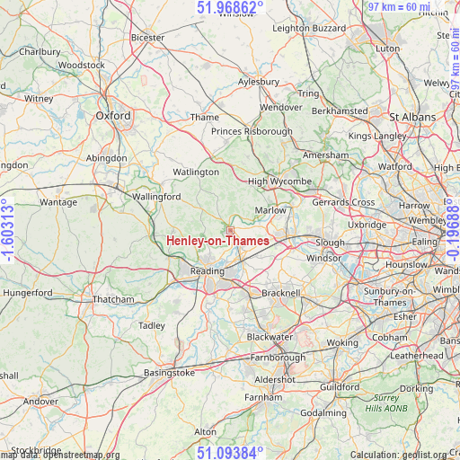
Henley-on-Thames GPS coordinates[2]
51° 31' 59.988" North, 0° 54' 0" West
| Map corner | latitude | longitude |
|---|---|---|
| Upper-left | 51.96862°, | -1.60313° |
| Center: | 51.53333°, | -0.9° |
| Lower-right: | 51.09384°, | -0.19688° |
| Map W x H: | 97.3×97.3 km | = 60.5×60.5mi |
| max Lat: | 60.39635° ⇑76.7% North |
| Henley-on-Thames: | 51.53333° |
| min Lat: | ⇓23.3% South 34.60088° |
| min Long | Henley-on-Thame | max Long |
| -7.64133° | -0.9° | 32.95536° |
| W 68.4%⇐ | ⇒31.6% E |
Elevation
Elevation of Henley-on-Thames is 34 m = 112 ft, and this is 38.9 m = 128 ft below average elevation for this country.
| Max E: |
515 m = 1690 ft | 69.2% |
| Avg. | 72.9 m = 239 ft | |
| Henley-on-Thames | 34 m = 112 ft | |
Min E: |
-30 m = -98 ft | 30.8% |
See also: United Kingdom elevation on elevation.city.
Geographical zone
Henley-on-Thames is located in North temperate zone (between Tropic of Cancer and the Arctic Circle). Distance of this North polar circle is 1671.2 km =1038.4 mi to North.| Distance of | km | miles | from Henley-on-Thames |
|---|---|---|---|
| North Pole | 4277.1 | 2657.7 | to North |
| Arctic Circle | 1671.2 | 1038.4 | to North |
| Tropic Cancer | 3124.1 | 1941.2 | to South |
| Equator | 5730 | 3560.5 | to South |


Nearby cities:
15 places around Henley-on-Thames: (largest is in red/bold)
• Binfield Heath
4.1 km =2.5 mi,  206°
206°
• Bisham
9 km =5.6 mi,  69°
69°
• Charvil
6.5 km =4 mi,  171°
171°
• Frieth
8.7 km =5.4 mi,  22°
22°
• Hurley
6.4 km =4 mi,  76°
76°
• Knowl Hill
6.4 km =4 mi,  117°
117°
• Nettlebed
7.8 km =4.8 mi,  307°
307°
• Remenham
2.2 km =1.4 mi, 17°
• Rotherfield Peppard
5.4 km =3.4 mi,  266°
266°
• Shiplake
3.6 km =2.2 mi,  182°
182°
• Sonning
6.6 km =4.1 mi,  187°
187°
• Sonning Common
5.6 km =3.5 mi,  253°
253°
• Twyford
7 km =4.3 mi,  157°
157°
• Waltham St Lawrence
8.4 km =5.2 mi,  129°
129°
• Wargrave
4.3 km =2.7 mi,  146°
146°
Sources, notices
• [Note1] Compared only with cities in United Kingdom existing in our database
• [Src1] Map data: © OpenStreetMap contributors (CC-BY-SA)
• [Src2] Other city data from geonames.org with taken over terms of usage.
• [Src3] Geographical zone / Annual Mean Temperature by Robert A. Rohde @ Wikipedia
