Hayes geodata
Hayes (England) is a populated place; located in United Kingdom in Europe/London (GMT+1) time zone. With population of 50,000 people, there are 234 cities with bigger population in this country. Compared to other cities in United Kingdom, 77.2% of cities are located further ↑North; 78.4% of cities are located further ←West and 65.5% of cities have higher elevation than Hayes. Note1


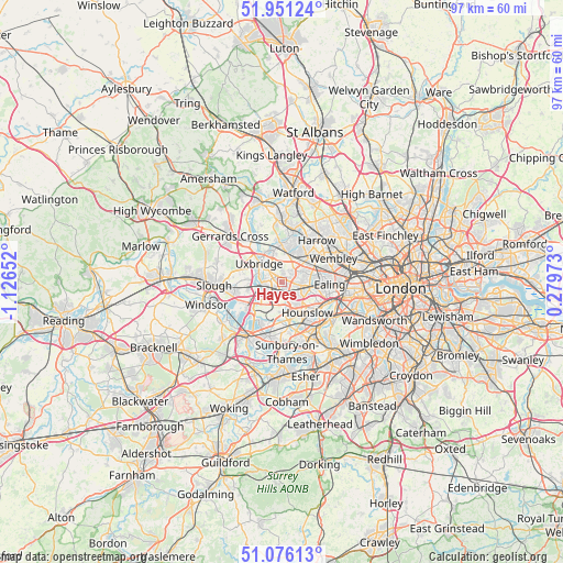
Hayes GPS coordinates[2]
51° 30' 56.844" North, 0° 25' 24.24" West
| Map corner | latitude | longitude |
|---|---|---|
| Upper-left | 51.95124°, | -1.12652° |
| Center: | 51.51579°, | -0.4234° |
| Lower-right: | 51.07613°, | 0.27973° |
| Map W x H: | 97.3×97.3 km | = 60.5×60.5mi |
| max Lat: | 60.39635° ⇑77.2% North |
| Hayes: | 51.51579° |
| min Lat: | ⇓22.8% South 34.60088° |
| min Long | Hayes | max Long |
| -7.64133° | -0.4234° | 32.95536° |
| W 78.4%⇐ | ⇒21.6% E |
Elevation
Elevation of Hayes is 39 m = 128 ft, and this is 33.9 m = 111 ft below average elevation for this country.
| Max E: |
515 m = 1690 ft | 65.5% |
| Avg. | 72.9 m = 239 ft | |
| Hayes | 39 m = 128 ft | |
Min E: |
-30 m = -98 ft | 34.5% |
See also: Hayes elevation on elevation.city.
Geographical zone
Hayes is located in North temperate zone (between Tropic of Cancer and the Arctic Circle). Distance of this North polar circle is 1673.2 km =1039.7 mi to North.| Distance of | km | miles | from Hayes |
|---|---|---|---|
| North Pole | 4279 | 2658.8 | to North |
| Arctic Circle | 1673.2 | 1039.7 | to North |
| Tropic Cancer | 3122.1 | 1940 | to South |
| Equator | 5728 | 3559.2 | to South |


Nearby cities:
15 places around Hayes: (largest is in red/bold)
• Colnbrook
7.7 km =4.8 mi,  242°
242°
• Denham
7.8 km =4.8 mi,  316°
316°
• Ealing
8.4 km =5.2 mi,  92°
92°
• Feltham
7.8 km =4.8 mi,  175°
175°
• Greenford
4.9 km =3 mi,  73°
73°
• Harmondsworth
4.8 km =3 mi,  230°
230°
• Hounslow
6.8 km =4.2 mi,  140°
140°
• Isleworth
7.2 km =4.5 mi,  128°
128°
• Iver
5.6 km =3.5 mi,  251°
251°
• Iver Heath
6.9 km =4.3 mi,  289°
289°
• Northolt
5.3 km =3.3 mi,  46°
46°
• Ruislip
6.4 km =4 mi,  359°
359°
• Southall
3.7 km =2.3 mi,  101°
101°
• Uxbridge
5.5 km =3.4 mi,  312°
312°
• West Drayton
3.5 km =2.2 mi, 239°
Sources, notices
• [Note1] Compared only with cities in United Kingdom existing in our database
• [Src1] Map data: © OpenStreetMap contributors (CC-BY-SA)
• [Src2] Other city data from geonames.org with taken over terms of usage.
• [Src3] Geographical zone / Annual Mean Temperature by Robert A. Rohde @ Wikipedia
