Hounslow geodata
Hounslow (England) is a seat of a third-order administrative division; located in United Kingdom in Europe/London (GMT+0) time zone. With population of 66,292 people, there are 159 cities with bigger population in this country. Compared to other cities in United Kingdom, 78.8% of cities are located further ↑North; 79.6% of cities are located further ←West and 76.3% of cities have higher elevation than Hounslow. Note1


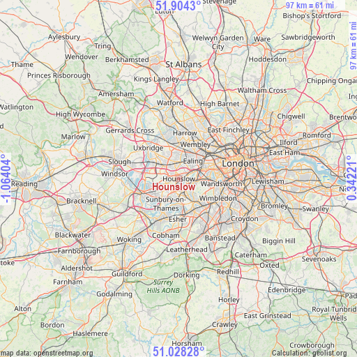
Hounslow GPS coordinates[2]
51° 28' 6.204" North, 0° 21' 39.312" West
| Map corner | latitude | longitude |
|---|---|---|
| Upper-left | 51.9043°, | -1.06404° |
| Center: | 51.46839°, | -0.36092° |
| Lower-right: | 51.02828°, | 0.34221° |
| Map W x H: | 97.4×97.4 km | = 60.5×60.5mi |
| max Lat: | 60.39635° ⇑78.8% North |
| Hounslow: | 51.46839° |
| min Lat: | ⇓21.2% South 34.60088° |
| min Long | Hounslow | max Long |
| -7.64133° | -0.36092° | 32.95536° |
| W 79.6%⇐ | ⇒20.4% E |
Elevation
Elevation of Hounslow is 25 m = 82 ft, and this is 47.9 m = 157 ft below average elevation for this country.
| Max E: |
515 m = 1690 ft | 76.3% |
| Avg. | 72.9 m = 239 ft | |
| Hounslow | 25 m = 82 ft | |
Min E: |
-30 m = -98 ft | 23.7% |
See also: Hounslow elevation on elevation.city.
Geographical zone
Hounslow is located in North temperate zone (between Tropic of Cancer and the Arctic Circle). Distance of this North polar circle is 1678.4 km =1042.9 mi to North.| Distance of | km | miles | from Hounslow |
|---|---|---|---|
| North Pole | 4284.3 | 2662.1 | to North |
| Arctic Circle | 1678.4 | 1042.9 | to North |
| Tropic Cancer | 3116.8 | 1936.7 | to South |
| Equator | 5722.7 | 3555.9 | to South |


Nearby cities:
15 places around Hounslow: (largest is in red/bold)
• Acton
7.4 km =4.6 mi,  52°
52°
• Brentford
4.1 km =2.5 mi,  61°
61°
• Ealing
6.3 km =3.9 mi,  39°
39°
• Ealing Broadway
6.7 km =4.2 mi, 38°
• Feltham
4.4 km =2.7 mi,  236°
236°
• Greenford
6.7 km =4.2 mi,  3°
3°
• Hampton
6.1 km =3.8 mi,  183°
183°
• Hayes
6.8 km =4.2 mi,  320°
320°
• Isleworth
1.5 km =0.9 mi, 59°
• Kingston upon Thames
7.6 km =4.7 mi,  144°
144°
• Richmond
3.9 km =2.4 mi,  101°
101°
• Southall
4.6 km =2.9 mi,  350°
350°
• Teddington
5.5 km =3.4 mi,  157°
157°
• Twickenham
3.1 km =1.9 mi,  148°
148°
• West Molesey
7.7 km =4.8 mi,  189°
189°
Sources, notices
• [Note1] Compared only with cities in United Kingdom existing in our database
• [Src1] Map data: © OpenStreetMap contributors (CC-BY-SA)
• [Src2] Other city data from geonames.org with taken over terms of usage.
• [Src3] Geographical zone / Annual Mean Temperature by Robert A. Rohde @ Wikipedia
