Hartlepool geodata
Hartlepool (England) is a seat of a second-order administrative division; located in United Kingdom in Europe/London (GMT+1) time zone. With population of 88,855 people, there are 114 cities with bigger population in this country. Compared to other cities in United Kingdom, 84% of cities are located further ↓South; 62.4% of cities are located further ←West and 99.9% of cities have higher elevation than Hartlepool. Note1


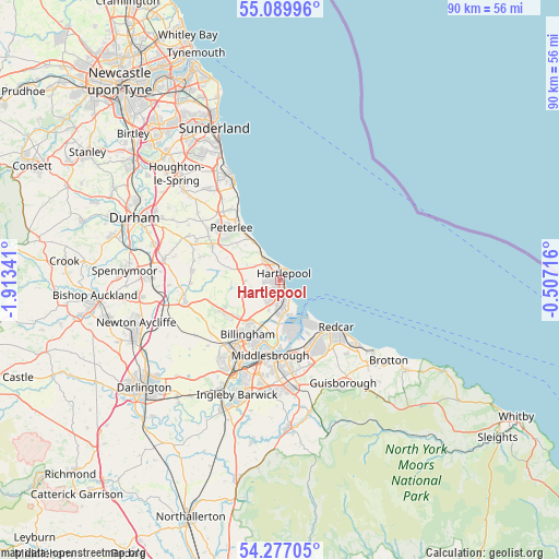
Hartlepool GPS coordinates[2]
54° 41' 7.944" North, 1° 12' 37.008" West
| Map corner | latitude | longitude |
|---|---|---|
| Upper-left | 55.08996°, | -1.91341° |
| Center: | 54.68554°, | -1.21028° |
| Lower-right: | 54.27705°, | -0.50716° |
| Map W x H: | 90.4×90.4 km | = 56.2×56.2mi |
| max Lat: | 60.39635° ⇑16% North |
| Hartlepool: | 54.68554° |
| min Lat: | ⇓84% South 34.60088° |
| min Long | Hartlepool | max Long |
| -7.64133° | -1.21028° | 32.95536° |
| W 62.4%⇐ | ⇒37.6% E |
Elevation
Elevation of Hartlepool is 1 m = 3 ft, and this is 71.9 m = 236 ft below average elevation for this country.
| Max E: |
515 m = 1690 ft | 99.9% |
| Avg. | 72.9 m = 239 ft | |
| Hartlepool | 1 m = 3 ft | |
Min E: |
-30 m = -98 ft | 0.1% |
See also: Hartlepool elevation on elevation.city.
Geographical zone
Hartlepool is located in North temperate zone (between Tropic of Cancer and the Arctic Circle). Distance of this North polar circle is 1320.7 km =820.6 mi to North.| Distance of | km | miles | from Hartlepool |
|---|---|---|---|
| North Pole | 3926.6 | 2439.9 | to North |
| Arctic Circle | 1320.7 | 820.6 | to North |
| Tropic Cancer | 3474.5 | 2159 | to South |
| Equator | 6080.5 | 3778.2 | to South |


Nearby cities:
15 places around Hartlepool: (largest is in red/bold)
• Billingham
11.9 km =7.4 mi,  205°
205°
• Easington
14.6 km =9.1 mi,  319°
319°
• Easington Colliery
13.7 km =8.5 mi,  326°
326°
• Elwick
5.5 km =3.4 mi,  268°
268°
• Fishburn
14.5 km =9 mi, 268°
• Greatham
5.2 km =3.2 mi,  200°
200°
• Grindon
13.5 km =8.4 mi,  235°
235°
• Middlesbrough
12.3 km =7.6 mi,  187°
187°
• Peterlee
11.6 km =7.2 mi, 315°
• Redcar
12.3 km =7.6 mi,  128°
128°
• South Bank
13.8 km =8.6 mi,  163°
163°
• Stockton-on-Tees
14.8 km =9.2 mi, 208°
• Trimdon
14.1 km =8.8 mi,  275°
275°
• Trimdon Grange
14.2 km =8.8 mi, 282°
• Wingate
12 km =7.5 mi,  295°
295°
Sources, notices
• [Note1] Compared only with cities in United Kingdom existing in our database
• [Src1] Map data: © OpenStreetMap contributors (CC-BY-SA)
• [Src2] Other city data from geonames.org with taken over terms of usage.
• [Src3] Geographical zone / Annual Mean Temperature by Robert A. Rohde @ Wikipedia
