Hamble-le-Rice geodata
Hamble-le-Rice (England) is a populated place; located in United Kingdom in Europe/London (GMT+1) time zone. With population of 3,939 people, there are 1860 cities with bigger population in this country. Compared to other cities in United Kingdom, 94% of cities are located further ↑North; 59.5% of cities are located further ←West and 84.7% of cities have higher elevation than Hamble-le-Rice. Note1
Administrative division(s):
- Level 1: England
- Level 2: Hampshire
- Level 3: Eastleigh District
- Level 4: Hamble-le-Rice


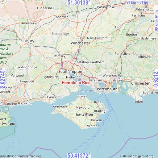
Hamble-le-Rice GPS coordinates[2]
50° 51' 34.776" North, 1° 19' 27.552" West
| Map corner | latitude | longitude |
|---|---|---|
| Upper-left | 51.30138°, | -2.02745° |
| Center: | 50.85966°, | -1.32432° |
| Lower-right: | 50.41372°, | -0.6212° |
| Map W x H: | 98.7×98.7 km | = 61.3×61.3mi |
| max Lat: | 60.39635° ⇑94% North |
| Hamble-le-Rice: | 50.85966° |
| min Lat: | ⇓6% South 34.60088° |
| min Long | Hamble-le-Rice | max Long |
| -7.64133° | -1.32432° | 32.95536° |
| W 59.5%⇐ | ⇒40.5% E |
Elevation
Elevation of Hamble-le-Rice is 16 m = 52 ft, and this is 56.9 m = 187 ft below average elevation for this country.
| Max E: |
515 m = 1690 ft | 84.7% |
| Avg. | 72.9 m = 239 ft | |
| Hamble-le-Rice | 16 m = 52 ft | |
Min E: |
-30 m = -98 ft | 15.3% |
See also: United Kingdom elevation on elevation.city.
Geographical zone
Hamble-le-Rice is located in North temperate zone (between Tropic of Cancer and the Arctic Circle). Distance of this North polar circle is 1746.1 km =1085 mi to North.| Distance of | km | miles | from Hamble-le-Rice |
|---|---|---|---|
| North Pole | 4352 | 2704.2 | to North |
| Arctic Circle | 1746.1 | 1085 | to North |
| Tropic Cancer | 3049.1 | 1894.6 | to South |
| Equator | 5655.1 | 3513.9 | to South |


Nearby cities:
15 places around Hamble-le-Rice: (largest is in red/bold)
• Botley
7.2 km =4.5 mi,  32°
32°
• Bursledon
3.1 km =1.9 mi,  11°
11°
• Cowes
10.9 km =6.8 mi,  170°
170°
• Curdridge
9 km =5.6 mi,  37°
37°
• East Cowes
11.6 km =7.2 mi, 167°
• Fareham
10.2 km =6.3 mi,  95°
95°
• Gurnard
11 km =6.8 mi,  179°
179°
• Hedge End
6.1 km =3.8 mi,  15°
15°
• Hythe
5.4 km =3.4 mi,  270°
270°
• Lee-on-the-Solent
10.8 km =6.7 mi,  126°
126°
• Marchwood
9.7 km =6 mi,  290°
290°
• Netley
2.8 km =1.7 mi,  311°
311°
• Southampton
7.5 km =4.7 mi, 311°
• West End
7.6 km =4.7 mi,  355°
355°
• Wickham
10.5 km =6.5 mi,  65°
65°
Sources, notices
• [Note1] Compared only with cities in United Kingdom existing in our database
• [Src1] Map data: © OpenStreetMap contributors (CC-BY-SA)
• [Src2] Other city data from geonames.org with taken over terms of usage.
• [Src3] Geographical zone / Annual Mean Temperature by Robert A. Rohde @ Wikipedia
