Southampton geodata
Southampton (England) is a seat of a second-order administrative division; located in United Kingdom in Europe/London (GMT+1) time zone. With population of 246,201 people, there are 31 cities with bigger population in this country. Compared to other cities in United Kingdom, 93.3% of cities are located further ↑North; 57.6% of cities are located further ←West and 82% of cities have higher elevation than Southampton. Note1


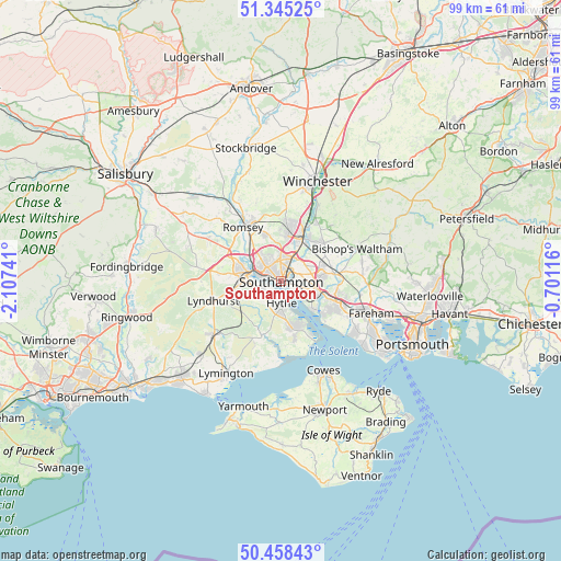
Southampton GPS coordinates[2]
50° 54' 14.22" North, 1° 24' 15.408" West
| Map corner | latitude | longitude |
|---|---|---|
| Upper-left | 51.34525°, | -2.10741° |
| Center: | 50.90395°, | -1.40428° |
| Lower-right: | 50.45843°, | -0.70116° |
| Map W x H: | 98.6×98.6 km | = 61.3×61.3mi |
| max Lat: | 60.39635° ⇑93.3% North |
| Southampton: | 50.90395° |
| min Lat: | ⇓6.7% South 34.60088° |
| min Long | Southampton | max Long |
| -7.64133° | -1.40428° | 32.95536° |
| W 57.6%⇐ | ⇒42.4% E |
Elevation
Elevation of Southampton is 19 m = 62 ft, and this is 53.9 m = 177 ft below average elevation for this country.
| Max E: |
515 m = 1690 ft | 82% |
| Avg. | 72.9 m = 239 ft | |
| Southampton | 19 m = 62 ft | |
Min E: |
-30 m = -98 ft | 18% |
See also: Southampton elevation on elevation.city.
Geographical zone
Southampton is located in North temperate zone (between Tropic of Cancer and the Arctic Circle). Distance of this North polar circle is 1741.2 km =1081.9 mi to North.| Distance of | km | miles | from Southampton |
|---|---|---|---|
| North Pole | 4347.1 | 2701.2 | to North |
| Arctic Circle | 1741.2 | 1081.9 | to North |
| Tropic Cancer | 3054.1 | 1897.7 | to South |
| Equator | 5660 | 3517 | to South |


Nearby cities:
15 places around Southampton: (largest is in red/bold)
• Bishopstoke
8.8 km =5.5 mi,  37°
37°
• Botley
9.5 km =5.9 mi,  83°
83°
• Bursledon
6.5 km =4 mi,  107°
107°
• Colden Common
12 km =7.5 mi,  32°
32°
• Curdridge
11.3 km =7 mi, 78°
• Eastleigh
7.9 km =4.9 mi, 28°
• Hamble-le-Rice
7.5 km =4.7 mi,  131°
131°
• Hedge End
7.3 km =4.5 mi, 82°
• Hythe
4.9 km =3 mi,  177°
177°
• Marchwood
3.9 km =2.4 mi,  245°
245°
• Netley
4.7 km =2.9 mi, 131°
• North Baddesley
8.7 km =5.4 mi,  340°
340°
• Romsey
11.6 km =7.2 mi,  324°
324°
• Totton
6.3 km =3.9 mi,  285°
285°
• West End
5.6 km =3.5 mi,  62°
62°
Sources, notices
• [Note1] Compared only with cities in United Kingdom existing in our database
• [Src1] Map data: © OpenStreetMap contributors (CC-BY-SA)
• [Src2] Other city data from geonames.org with taken over terms of usage.
• [Src3] Geographical zone / Annual Mean Temperature by Robert A. Rohde @ Wikipedia
