Gravesend geodata
Gravesend (England) is a seat of a third-order administrative division; located in United Kingdom in Europe/London (GMT+1) time zone. With population of 54,263 people, there are 212 cities with bigger population in this country. Compared to other cities in United Kingdom, 79.7% of cities are located further ↑North; 91% of cities are located further ←West and 79.9% of cities have higher elevation than Gravesend. Note1


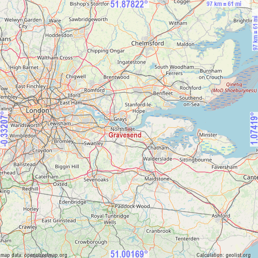
Gravesend GPS coordinates[2]
51° 26' 31.416" North, 0° 22' 15.816" East
| Map corner | latitude | longitude |
|---|---|---|
| Upper-left | 51.87822°, | -0.33207° |
| Center: | 51.44206°, | 0.37106° |
| Lower-right: | 51.00169°, | 1.07419° |
| Map W x H: | 97.5×97.5 km | = 60.6×60.6mi |
| max Lat: | 60.39635° ⇑79.7% North |
| Gravesend: | 51.44206° |
| min Lat: | ⇓20.3% South 34.60088° |
| min Long | Gravesend | max Long |
| -7.64133° | 0.37106° | 32.95536° |
| W 91%⇐ | ⇒9% E |
Elevation
Elevation of Gravesend is 21 m = 69 ft, and this is 51.9 m = 170 ft below average elevation for this country.
| Max E: |
515 m = 1690 ft | 79.9% |
| Avg. | 72.9 m = 239 ft | |
| Gravesend | 21 m = 69 ft | |
Min E: |
-30 m = -98 ft | 20.1% |
See also: Gravesend elevation on elevation.city.
Geographical zone
Gravesend is located in North temperate zone (between Tropic of Cancer and the Arctic Circle). Distance of this North polar circle is 1681.4 km =1044.8 mi to North.| Distance of | km | miles | from Gravesend |
|---|---|---|---|
| North Pole | 4287.2 | 2663.9 | to North |
| Arctic Circle | 1681.4 | 1044.8 | to North |
| Tropic Cancer | 3113.9 | 1934.9 | to South |
| Equator | 5719.8 | 3554.1 | to South |


Nearby cities:
15 places around Gravesend: (largest is in red/bold)
• Chadwell St Mary
4.4 km =2.7 mi,  353°
353°
• Chafford Hundred
7.5 km =4.7 mi,  314°
314°
• East Tilbury
5.3 km =3.3 mi,  36°
36°
• Grays
4.9 km =3 mi,  319°
319°
• Greenhithe
6 km =3.7 mi,  278°
278°
• Hartley
7.7 km =4.8 mi,  217°
217°
• Longfield
6.9 km =4.3 mi, 223°
• Meopham
8.2 km =5.1 mi,  185°
185°
• Orsett
7.8 km =4.8 mi,  358°
358°
• Sole Street
6.3 km =3.9 mi,  175°
175°
• Southfleet
4.5 km =2.8 mi,  230°
230°
• Stone
7.4 km =4.6 mi, 277°
• Swanscombe
4.2 km =2.6 mi, 277°
• Tilbury
2.4 km =1.5 mi,  339°
339°
• West Thurrock
7.7 km =4.8 mi,  301°
301°
Sources, notices
• [Note1] Compared only with cities in United Kingdom existing in our database
• [Src1] Map data: © OpenStreetMap contributors (CC-BY-SA)
• [Src2] Other city data from geonames.org with taken over terms of usage.
• [Src3] Geographical zone / Annual Mean Temperature by Robert A. Rohde @ Wikipedia
