Glyn-neath geodata
Glyn-neath (Wales) is a populated place; located in United Kingdom in Europe/London (GMT+1) time zone. With population of 5,419 people, there are 1563 cities with bigger population in this country. Compared to other cities in United Kingdom, 69.5% of cities are located further ↑North; 83.9% of cities are located further →East and 51.1% of cities have lower elevation than Glyn-neath. Note1


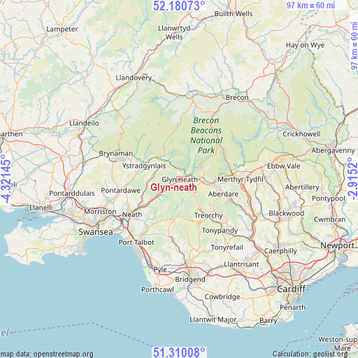
Glyn-neath GPS coordinates[2]
51° 44' 51" North, 3° 37' 5.988" West
| Map corner | latitude | longitude |
|---|---|---|
| Upper-left | 52.18073°, | -4.32145° |
| Center: | 51.7475°, | -3.61833° |
| Lower-right: | 51.31008°, | -2.9152° |
| Map W x H: | 96.8×96.8 km | = 60.1×60.1mi |
| max Lat: | 60.39635° ⇑69.5% North |
| Glyn-neath: | 51.7475° |
| min Lat: | ⇓30.5% South 34.60088° |
| min Long | Glyn-neath | max Long |
| -7.64133° | -3.61833° | 32.95536° |
| W 16.1%⇐ | ⇒83.9% E |
Elevation
Elevation of Glyn-neath is 62 m = 203 ft, and this is 10.9 m = 36 ft below average elevation for this country.
| Max E: |
515 m = 1690 ft | 48.9% |
| Avg. | 72.9 m = 239 ft | |
| Glyn-neath | 62 m = 203 ft | |
Min E: |
-30 m = -98 ft | 51.1% |
See also: United Kingdom elevation on elevation.city.
Geographical zone
Glyn-neath is located in North temperate zone (between Tropic of Cancer and the Arctic Circle). Distance of this North polar circle is 1647.4 km =1023.6 mi to North.| Distance of | km | miles | from Glyn-neath |
|---|---|---|---|
| North Pole | 4253.3 | 2642.9 | to North |
| Arctic Circle | 1647.4 | 1023.6 | to North |
| Tropic Cancer | 3147.9 | 1956 | to South |
| Equator | 5753.8 | 3575.2 | to South |


Nearby cities:
15 places around Glyn-neath: (largest is in red/bold)
• Aberdare
12.2 km =7.6 mi,  107°
107°
• Blaengwynfi
10.2 km =6.3 mi,  174°
174°
• Coelbren
6.1 km =3.8 mi,  324°
324°
• Croeserw
11.5 km =7.1 mi,  187°
187°
• Crynant
9.2 km =5.7 mi,  256°
256°
• Glyncorrwg
7.6 km =4.7 mi, 185°
• Hirwaun
7.5 km =4.7 mi,  97°
97°
• Maerdy
12.1 km =7.5 mi,  131°
131°
• Resolven
6.7 km =4.2 mi,  234°
234°
• Rhigos
3.9 km =2.4 mi, 98°
• Seven Sisters
7.1 km =4.4 mi,  287°
287°
• Treherbert
10.4 km =6.5 mi,  144°
144°
• Treorchy
12.5 km =7.8 mi, 141°
• Ystalyfera
11.4 km =7.1 mi,  281°
281°
• Ystradgynlais
10.4 km =6.5 mi, 281°
Sources, notices
• [Note1] Compared only with cities in United Kingdom existing in our database
• [Src1] Map data: © OpenStreetMap contributors (CC-BY-SA)
• [Src2] Other city data from geonames.org with taken over terms of usage.
• [Src3] Geographical zone / Annual Mean Temperature by Robert A. Rohde @ Wikipedia
