Folkestone geodata
Folkestone (England) is a populated place; located in United Kingdom in Europe/London (GMT+1) time zone. With population of 66,429 people, there are 157 cities with bigger population in this country. Compared to other cities in United Kingdom, 89.7% of cities are located further ↑North; 97.6% of cities are located further ←West and 60.2% of cities have higher elevation than Folkestone. Note1
Administrative division(s):
- Level 1: England
- Level 2: Kent
- Level 3: Shepway District
- Level 4: Folkestone


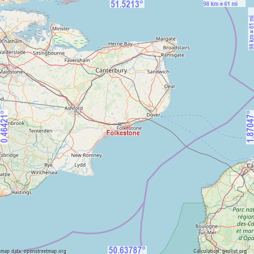
Folkestone GPS coordinates[2]
51° 4' 54.084" North, 1° 10' 2.424" East
| Map corner | latitude | longitude |
|---|---|---|
| Upper-left | 51.5213°, | 0.46421° |
| Center: | 51.08169°, | 1.16734° |
| Lower-right: | 50.63787°, | 1.87047° |
| Map W x H: | 98.2×98.2 km | = 61×61mi |
| max Lat: | 60.39635° ⇑89.7% North |
| Folkestone: | 51.08169° |
| min Lat: | ⇓10.3% South 34.60088° |
| min Long | Folkestone | max Long |
| -7.64133° | 1.16734° | 32.95536° |
| W 97.6%⇐ | ⇒2.4% E |
Elevation
Elevation of Folkestone is 46 m = 151 ft, and this is 26.9 m = 88 ft below average elevation for this country.
| Max E: |
515 m = 1690 ft | 60.2% |
| Avg. | 72.9 m = 239 ft | |
| Folkestone | 46 m = 151 ft | |
Min E: |
-30 m = -98 ft | 39.8% |
See also: Folkestone elevation on elevation.city.
Geographical zone
Folkestone is located in North temperate zone (between Tropic of Cancer and the Arctic Circle). Distance of this North polar circle is 1721.4 km =1069.6 mi to North.| Distance of | km | miles | from Folkestone |
|---|---|---|---|
| North Pole | 4327.3 | 2688.9 | to North |
| Arctic Circle | 1721.4 | 1069.6 | to North |
| Tropic Cancer | 3073.8 | 1910 | to South |
| Equator | 5679.8 | 3529.3 | to South |


Nearby cities:
15 places around Folkestone: (largest is in red/bold)
• Barham
13.8 km =8.6 mi,  357°
357°
• Capel le Ferne
3.9 km =2.4 mi,  52°
52°
• Densole
5.4 km =3.4 mi,  353°
353°
• Dover
11.3 km =7 mi,  64°
64°
• Dymchurch
13.6 km =8.5 mi,  242°
242°
• Elham
8.8 km =5.5 mi,  333°
333°
• Eythorne
14.6 km =9.1 mi,  28°
28°
• Hawkinge
3.5 km =2.2 mi, 353°
• Hythe
5.9 km =3.7 mi,  258°
258°
• Lydden
10.2 km =6.3 mi, 27°
• Lyminge
7.6 km =4.7 mi,  314°
314°
• Lympne
9.7 km =6 mi,  267°
267°
• Sellindge
11.5 km =7.1 mi,  281°
281°
• Shepherdswell
12.5 km =7.8 mi,  20°
20°
• Wootton
10.3 km =6.4 mi,  4°
4°
Sources, notices
• [Note1] Compared only with cities in United Kingdom existing in our database
• [Src1] Map data: © OpenStreetMap contributors (CC-BY-SA)
• [Src2] Other city data from geonames.org with taken over terms of usage.
• [Src3] Geographical zone / Annual Mean Temperature by Robert A. Rohde @ Wikipedia
