Felixstowe geodata
Felixstowe (England) is a populated place; located in United Kingdom in Europe/London (GMT+1) time zone. With population of 29,171 people, there are 419 cities with bigger population in this country. Compared to other cities in United Kingdom, 63.2% of cities are located further ↑North; 98.7% of cities are located further ←West and 79% of cities have higher elevation than Felixstowe. Note1
Administrative division(s):
- Level 1: England
- Level 2: Suffolk
- Level 3: Suffolk Coastal District
- Level 4: Felixstowe


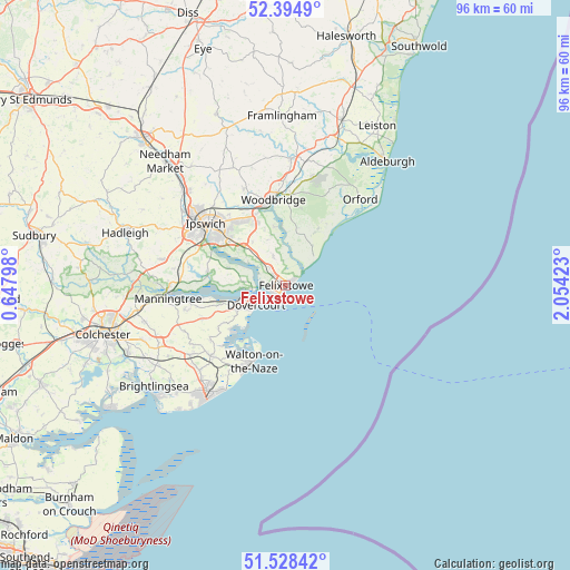
Felixstowe GPS coordinates[2]
51° 57' 49.5" North, 1° 21' 3.96" East
| Map corner | latitude | longitude |
|---|---|---|
| Upper-left | 52.3949°, | 0.64798° |
| Center: | 51.96375°, | 1.3511° |
| Lower-right: | 51.52842°, | 2.05423° |
| Map W x H: | 96.3×96.3 km | = 59.8×59.8mi |
| max Lat: | 60.39635° ⇑63.2% North |
| Felixstowe: | 51.96375° |
| min Lat: | ⇓36.8% South 34.60088° |
| min Long | Felixstowe | max Long |
| -7.64133° | 1.3511° | 32.95536° |
| W 98.7%⇐ | ⇒1.3% E |
Elevation
Elevation of Felixstowe is 22 m = 72 ft, and this is 50.9 m = 167 ft below average elevation for this country.
| Max E: |
515 m = 1690 ft | 79% |
| Avg. | 72.9 m = 239 ft | |
| Felixstowe | 22 m = 72 ft | |
Min E: |
-30 m = -98 ft | 21% |
See also: United Kingdom elevation on elevation.city.
Geographical zone
Felixstowe is located in North temperate zone (between Tropic of Cancer and the Arctic Circle). Distance of this North polar circle is 1623.3 km =1008.7 mi to North.| Distance of | km | miles | from Felixstowe |
|---|---|---|---|
| North Pole | 4229.2 | 2627.9 | to North |
| Arctic Circle | 1623.3 | 1008.7 | to North |
| Tropic Cancer | 3171.9 | 1970.9 | to South |
| Equator | 5777.8 | 3590.2 | to South |


Nearby cities:
15 places around Felixstowe: (largest is in red/bold)
• Bucklesham
9.3 km =5.8 mi,  322°
322°
• Chelmondiston
10 km =6.2 mi,  286°
286°
• Dovercourt
5.8 km =3.6 mi,  238°
238°
• Frinton-on-Sea
16.5 km =10.3 mi,  206°
206°
• Great Oakley
13.1 km =8.1 mi, 238°
• Harwich
5.2 km =3.2 mi, 242°
• Holbrook
13.4 km =8.3 mi,  279°
279°
• Hollesley
11 km =6.8 mi,  29°
29°
• Ipswich
17.1 km =10.6 mi,  308°
308°
• Kesgrave
13.5 km =8.4 mi, 324°
• Shotley
6.9 km =4.3 mi, 275°
• Shotley Gate
5.7 km =3.5 mi,  263°
263°
• Stutton
15 km =9.3 mi,  272°
272°
• Walton-on-the-Naze
14.1 km =8.8 mi,  204°
204°
• Woodbridge
14.6 km =9.1 mi,  351°
351°
Sources, notices
• [Note1] Compared only with cities in United Kingdom existing in our database
• [Src1] Map data: © OpenStreetMap contributors (CC-BY-SA)
• [Src2] Other city data from geonames.org with taken over terms of usage.
• [Src3] Geographical zone / Annual Mean Temperature by Robert A. Rohde @ Wikipedia
