Farnborough geodata
Farnborough (England) is a populated place; located in United Kingdom in Europe/London (GMT+1) time zone. With population of 59,902 people, there are 188 cities with bigger population in this country. Compared to other cities in United Kingdom, 84.4% of cities are located further ↑North; 71.2% of cities are located further ←West and 55.3% of cities have lower elevation than Farnborough. Note1


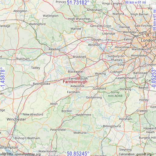
Farnborough GPS coordinates[2]
51° 17' 39.264" North, 0° 45' 20.34" West
| Map corner | latitude | longitude |
|---|---|---|
| Upper-left | 51.73182°, | -1.45878° |
| Center: | 51.29424°, | -0.75565° |
| Lower-right: | 50.85245°, | -0.05253° |
| Map W x H: | 97.8×97.8 km | = 60.8×60.8mi |
| max Lat: | 60.39635° ⇑84.4% North |
| Farnborough: | 51.29424° |
| min Lat: | ⇓15.6% South 34.60088° |
| min Long | Farnborough | max Long |
| -7.64133° | -0.75565° | 32.95536° |
| W 71.2%⇐ | ⇒28.8% E |
Elevation
Elevation of Farnborough is 69 m = 226 ft, and this is 3.9 m = 13 ft below average elevation for this country.
| Max E: |
515 m = 1690 ft | 44.7% |
| Avg. | 72.9 m = 239 ft | |
| Farnborough | 69 m = 226 ft | |
Min E: |
-30 m = -98 ft | 55.3% |
See also: Farnborough elevation on elevation.city.
Geographical zone
Farnborough is located in North temperate zone (between Tropic of Cancer and the Arctic Circle). Distance of this North polar circle is 1697.8 km =1055 mi to North.| Distance of | km | miles | from Farnborough |
|---|---|---|---|
| North Pole | 4303.7 | 2674.2 | to North |
| Arctic Circle | 1697.8 | 1055 | to North |
| Tropic Cancer | 3097.5 | 1924.7 | to South |
| Equator | 5703.4 | 3543.9 | to South |


Nearby cities:
15 places around Farnborough: (largest is in red/bold)
• Aldershot
5.1 km =3.2 mi,  186°
186°
• Bagshot
8.8 km =5.5 mi,  32°
32°
• Camberley
4.8 km =3 mi,  10°
10°
• Crowthorne
8.8 km =5.5 mi,  343°
343°
• Farnham
9.4 km =5.8 mi,  199°
199°
• Fleet
5.5 km =3.4 mi,  257°
257°
• Frimley
2.6 km =1.6 mi,  15°
15°
• Hale
7.6 km =4.7 mi, 197°
• Lightwater
8.4 km =5.2 mi,  44°
44°
• Normandy
7 km =4.3 mi,  125°
125°
• Pirbright
7.5 km =4.7 mi,  92°
92°
• Sandhurst
6.2 km =3.9 mi, 339°
• Seale
8.2 km =5.1 mi,  162°
162°
• Wood Street Village
9.6 km =6 mi,  120°
120°
• Yateley
7.5 km =4.7 mi,  316°
316°
Sources, notices
• [Note1] Compared only with cities in United Kingdom existing in our database
• [Src1] Map data: © OpenStreetMap contributors (CC-BY-SA)
• [Src2] Other city data from geonames.org with taken over terms of usage.
• [Src3] Geographical zone / Annual Mean Temperature by Robert A. Rohde @ Wikipedia
