Aldershot geodata
Aldershot (England) is a populated place; located in United Kingdom in Europe/London (GMT+1) time zone. With population of 61,339 people, there are 177 cities with bigger population in this country. Compared to other cities in United Kingdom, 85.6% of cities are located further ↑North; 71% of cities are located further ←West and 71.7% of cities have lower elevation than Aldershot. Note1


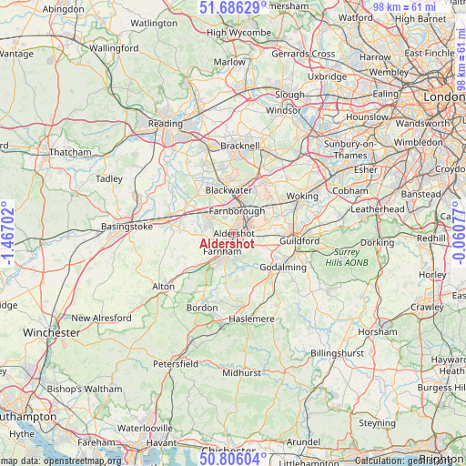
Aldershot GPS coordinates[2]
51° 14' 53.772" North, 0° 45' 50.004" West
| Map corner | latitude | longitude |
|---|---|---|
| Upper-left | 51.68629°, | -1.46702° |
| Center: | 51.24827°, | -0.76389° |
| Lower-right: | 50.80604°, | -0.06077° |
| Map W x H: | 97.9×97.9 km | = 60.8×60.8mi |
| max Lat: | 60.39635° ⇑85.6% North |
| Aldershot: | 51.24827° |
| min Lat: | ⇓14.4% South 34.60088° |
| min Long | Aldershot | max Long |
| -7.64133° | -0.76389° | 32.95536° |
| W 71%⇐ | ⇒29% E |
Elevation
Elevation of Aldershot is 99 m = 325 ft, and this is 26.1 m = 86 ft above average elevation for this country.
| Max E: |
515 m = 1690 ft | 28.3% |
| Aldershot | 99 m 325 ft | |
| Avg. | 72.9 m = 239 ft | |
Min E: |
-30 m = -98 ft | 71.7% |
See also: Aldershot elevation on elevation.city.
Geographical zone
Aldershot is located in North temperate zone (between Tropic of Cancer and the Arctic Circle). Distance of this North polar circle is 1702.9 km =1058.1 mi to North.| Distance of | km | miles | from Aldershot |
|---|---|---|---|
| North Pole | 4308.8 | 2677.4 | to North |
| Arctic Circle | 1702.9 | 1058.1 | to North |
| Tropic Cancer | 3092.4 | 1921.5 | to South |
| Equator | 5698.3 | 3540.8 | to South |


Nearby cities:
15 places around Aldershot: (largest is in red/bold)
• Camberley
10 km =6.2 mi,  8°
8°
• Crondall
7.1 km =4.4 mi,  256°
256°
• Elstead
8.1 km =5 mi,  149°
149°
• Fairlands
10 km =6.2 mi,  81°
81°
• Farnborough
5.1 km =3.2 mi, 6°
• Farnham
4.5 km =2.8 mi,  214°
214°
• Fleet
6.2 km =3.9 mi,  308°
308°
• Frimley
7.7 km =4.8 mi, 9°
• Hale
2.7 km =1.7 mi,  219°
219°
• Normandy
6.3 km =3.9 mi, 80°
• Pirbright
9.4 km =5.8 mi,  59°
59°
• Puttenham
7.2 km =4.5 mi,  113°
113°
• Rushmoor
10 km =6.2 mi,  175°
175°
• Seale
4 km =2.5 mi,  131°
131°
• Wood Street Village
8.8 km =5.5 mi,  88°
88°
Sources, notices
• [Note1] Compared only with cities in United Kingdom existing in our database
• [Src1] Map data: © OpenStreetMap contributors (CC-BY-SA)
• [Src2] Other city data from geonames.org with taken over terms of usage.
• [Src3] Geographical zone / Annual Mean Temperature by Robert A. Rohde @ Wikipedia
