Easington geodata
Easington (England) is a seat of a third-order administrative division; located in United Kingdom in Europe/London (GMT+1) time zone. With population of 691 people, there are 4293 cities with bigger population in this country. Compared to other cities in United Kingdom, 72.9% of cities are located further ↓South; 88.1% of cities are located further ←West and 92.6% of cities have higher elevation than Easington. Note1


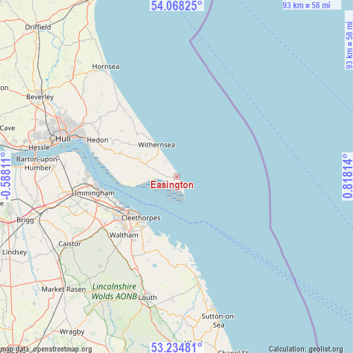
Easington GPS coordinates[2]
53° 39' 12.924" North, 0° 6' 54.036" East
| Map corner | latitude | longitude |
|---|---|---|
| Upper-left | 54.06825°, | -0.58811° |
| Center: | 53.65359°, | 0.11501° |
| Lower-right: | 53.23481°, | 0.81814° |
| Map W x H: | 92.7×92.7 km | = 57.6×57.6mi |
| max Lat: | 60.39635° ⇑27.1% North |
| Easington: | 53.65359° |
| min Lat: | ⇓72.9% South 34.60088° |
| min Long | Easington | max Long |
| -7.64133° | 0.11501° | 32.95536° |
| W 88.1%⇐ | ⇒11.9% E |
Elevation
Elevation of Easington is 10 m = 33 ft, and this is 62.9 m = 206 ft below average elevation for this country.
| Max E: |
515 m = 1690 ft | 92.6% |
| Avg. | 72.9 m = 239 ft | |
| Easington | 10 m = 33 ft | |
Min E: |
-30 m = -98 ft | 7.4% |
See also: United Kingdom elevation on elevation.city.
Geographical zone
Easington is located in North temperate zone (between Tropic of Cancer and the Arctic Circle). Distance of this North polar circle is 1435.5 km =892 mi to North.| Distance of | km | miles | from Easington |
|---|---|---|---|
| North Pole | 4041.3 | 2511.1 | to North |
| Arctic Circle | 1435.5 | 892 | to North |
| Tropic Cancer | 3359.8 | 2087.7 | to South |
| Equator | 5965.7 | 3706.9 | to South |


Nearby cities:
15 places around Easington: (largest is in red/bold)
• Burstwick
18.9 km =11.7 mi,  297°
297°
• Cleethorpes
14.2 km =8.8 mi,  223°
223°
• Grimbsy
17.5 km =10.9 mi,  233°
233°
• Grimsby
15.9 km =9.9 mi, 232°
• Halsham
15.1 km =9.4 mi, 304°
• Hollym
7.5 km =4.7 mi,  318°
318°
• Holmpton
5 km =3.1 mi, 319°
• Humberston
16.5 km =10.3 mi,  213°
213°
• Keyingham
16.3 km =10.1 mi,  292°
292°
• Ottringham
13.8 km =8.6 mi, 292°
• Patrington
9.1 km =5.7 mi, 291°
• Rimswell
13 km =8.1 mi, 318°
• Roos
15.2 km =9.4 mi, 316°
• Sunk Island
13.1 km =8.1 mi,  269°
269°
• Withernsea
10.2 km =6.3 mi,  328°
328°
Sources, notices
• [Note1] Compared only with cities in United Kingdom existing in our database
• [Src1] Map data: © OpenStreetMap contributors (CC-BY-SA)
• [Src2] Other city data from geonames.org with taken over terms of usage.
• [Src3] Geographical zone / Annual Mean Temperature by Robert A. Rohde @ Wikipedia
