Dunbar geodata
Dunbar (Scotland) is a populated place; located in United Kingdom in Europe/London (GMT+1) time zone. With population of 8,470 people, there are 1180 cities with bigger population in this country. Compared to other cities in United Kingdom, 94.1% of cities are located further ↓South; 65.4% of cities are located further →East and 79.9% of cities have higher elevation than Dunbar. Note1


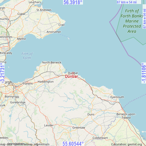
Dunbar GPS coordinates[2]
56° 0' 2.232" North, 2° 30' 51.048" West
| Map corner | latitude | longitude |
|---|---|---|
| Upper-left | 56.3918°, | -3.21731° |
| Center: | 56.00062°, | -2.51418° |
| Lower-right: | 55.60544°, | -1.81106° |
| Map W x H: | 87.4×87.4 km | = 54.3×54.3mi |
| max Lat: | 60.39635° ⇑5.9% North |
| Dunbar: | 56.00062° |
| min Lat: | ⇓94.1% South 34.60088° |
| min Long | Dunbar | max Long |
| -7.64133° | -2.51418° | 32.95536° |
| W 34.6%⇐ | ⇒65.4% E |
Elevation
Elevation of Dunbar is 21 m = 69 ft, and this is 51.9 m = 170 ft below average elevation for this country.
| Max E: |
515 m = 1690 ft | 79.9% |
| Avg. | 72.9 m = 239 ft | |
| Dunbar | 21 m = 69 ft | |
Min E: |
-30 m = -98 ft | 20.1% |
See also: United Kingdom elevation on elevation.city.
Geographical zone
Dunbar is located in North temperate zone (between Tropic of Cancer and the Arctic Circle). Distance of this North polar circle is 1174.5 km =729.8 mi to North.| Distance of | km | miles | from Dunbar |
|---|---|---|---|
| North Pole | 3780.4 | 2349 | to North |
| Arctic Circle | 1174.5 | 729.8 | to North |
| Tropic Cancer | 3620.8 | 2249.9 | to South |
| Equator | 6226.7 | 3869.1 | to South |


Nearby cities:
15 places around Dunbar: (largest is in red/bold)
• Aberlady
21.4 km =13.3 mi,  272°
272°
• Anstruther
27.4 km =17 mi,  334°
334°
• Coldingham
25.6 km =15.9 mi,  119°
119°
• Duns
27 km =16.8 mi,  157°
157°
• East Linton
9 km =5.6 mi,  260°
260°
• Gifford
18 km =11.2 mi,  233°
233°
• Gullane
19.9 km =12.4 mi,  281°
281°
• Haddington
17.5 km =10.9 mi,  253°
253°
• Longniddry
23.9 km =14.9 mi, 263°
• Macmerry
25.2 km =15.7 mi, 254°
• North Berwick
14.5 km =9 mi,  296°
296°
• Pencaitland
25.9 km =16.1 mi, 246°
• Pittenweem
27.2 km =16.9 mi, 330°
• Saint Monans
27.8 km =17.3 mi, 325°
• West Barns
2.6 km =1.6 mi, 252°
Sources, notices
• [Note1] Compared only with cities in United Kingdom existing in our database
• [Src1] Map data: © OpenStreetMap contributors (CC-BY-SA)
• [Src2] Other city data from geonames.org with taken over terms of usage.
• [Src3] Geographical zone / Annual Mean Temperature by Robert A. Rohde @ Wikipedia
