Dudley geodata
Dudley (England) is a seat of a second-order administrative division; located in United Kingdom in Europe/London (GMT+1) time zone. With population of 199,059 people, there are 38 cities with bigger population in this country. Compared to other cities in United Kingdom, 50.2% of cities are located further ↓South; 56.4% of cities are located further →East and 92% of cities have lower elevation than Dudley. Note1


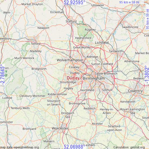
Dudley GPS coordinates[2]
52° 30' 0" North, 2° 4' 59.988" West
| Map corner | latitude | longitude |
|---|---|---|
| Upper-left | 52.92595°, | -2.78645° |
| Center: | 52.5°, | -2.08333° |
| Lower-right: | 52.06988°, | -1.3802° |
| Map W x H: | 95.2×95.2 km | = 59.2×59.2mi |
| max Lat: | 60.39635° ⇑49.8% North |
| Dudley: | 52.5° |
| min Lat: | ⇓50.2% South 34.60088° |
| min Long | Dudley | max Long |
| -7.64133° | -2.08333° | 32.95536° |
| W 43.6%⇐ | ⇒56.4% E |
Elevation
Elevation of Dudley is 161 m = 528 ft, and this is 88.1 m = 289 ft above average elevation for this country.
| Max E: |
515 m = 1690 ft | 8% |
| Dudley | 161 m 528 ft | |
| Avg. | 72.9 m = 239 ft | |
Min E: |
-30 m = -98 ft | 92% |
See also: Dudley elevation on elevation.city.
Geographical zone
Dudley is located in North temperate zone (between Tropic of Cancer and the Arctic Circle). Distance of this North polar circle is 1563.7 km =971.6 mi to North.| Distance of | km | miles | from Dudley |
|---|---|---|---|
| North Pole | 4169.6 | 2590.9 | to North |
| Arctic Circle | 1563.7 | 971.6 | to North |
| Tropic Cancer | 3231.5 | 2008 | to South |
| Equator | 5837.5 | 3627.3 | to South |


Nearby cities:
15 places around Dudley: (largest is in red/bold)
• Bilston
7.3 km =4.5 mi,  5°
5°
• Brierley Hill
3.3 km =2.1 mi,  231°
231°
• Cradley Heath
3.1 km =1.9 mi,  178°
178°
• Darlaston
8.1 km =5 mi,  24°
24°
• Halesowen
6.2 km =3.9 mi,  158°
158°
• Kingswinford
5.8 km =3.6 mi,  267°
267°
• Netherton
1.9 km =1.2 mi, 180°
• Oldbury
4.5 km =2.8 mi,  90°
90°
• Rowley Regis
3.3 km =2.1 mi,  125°
125°
• Smethwick
7.9 km =4.9 mi,  95°
95°
• Stourbridge
6.3 km =3.9 mi,  219°
219°
• Tipton
3.5 km =2.2 mi, 17°
• Wednesbury
7 km =4.3 mi,  35°
35°
• West Bromwich
6.4 km =4 mi,  70°
70°
• Wombourn
7.7 km =4.8 mi,  298°
298°
Sources, notices
• [Note1] Compared only with cities in United Kingdom existing in our database
• [Src1] Map data: © OpenStreetMap contributors (CC-BY-SA)
• [Src2] Other city data from geonames.org with taken over terms of usage.
• [Src3] Geographical zone / Annual Mean Temperature by Robert A. Rohde @ Wikipedia
