Halesowen geodata
Halesowen (England) is a populated place; located in United Kingdom in Europe/London (GMT+1) time zone. With population of 55,265 people, there are 207 cities with bigger population in this country. Compared to other cities in United Kingdom, 50.9% of cities are located further ↑North; 55.7% of cities are located further →East and 83.4% of cities have lower elevation than Halesowen. Note1


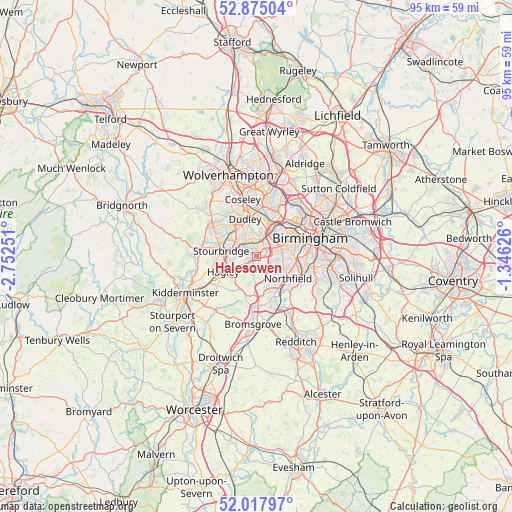
Halesowen GPS coordinates[2]
52° 26' 54.924" North, 2° 2' 57.768" West
| Map corner | latitude | longitude |
|---|---|---|
| Upper-left | 52.87504°, | -2.75251° |
| Center: | 52.44859°, | -2.04938° |
| Lower-right: | 52.01797°, | -1.34626° |
| Map W x H: | 95.3×95.3 km | = 59.2×59.2mi |
| max Lat: | 60.39635° ⇑50.9% North |
| Halesowen: | 52.44859° |
| min Lat: | ⇓49.1% South 34.60088° |
| min Long | Halesowen | max Long |
| -7.64133° | -2.04938° | 32.95536° |
| W 44.3%⇐ | ⇒55.7% E |
Elevation
Elevation of Halesowen is 128 m = 420 ft, and this is 55.1 m = 181 ft above average elevation for this country.
| Max E: |
515 m = 1690 ft | 16.6% |
| Halesowen | 128 m 420 ft | |
| Avg. | 72.9 m = 239 ft | |
Min E: |
-30 m = -98 ft | 83.4% |
See also: Halesowen elevation on elevation.city.
Geographical zone
Halesowen is located in North temperate zone (between Tropic of Cancer and the Arctic Circle). Distance of this North polar circle is 1569.4 km =975.2 mi to North.| Distance of | km | miles | from Halesowen |
|---|---|---|---|
| North Pole | 4175.3 | 2594.4 | to North |
| Arctic Circle | 1569.4 | 975.2 | to North |
| Tropic Cancer | 3225.8 | 2004.4 | to South |
| Equator | 5831.7 | 3623.6 | to South |


Nearby cities:
15 places around Halesowen: (largest is in red/bold)
• Bartley Green
3.8 km =2.4 mi,  112°
112°
• Belbroughton
7.9 km =4.9 mi,  216°
216°
• Brierley Hill
6.1 km =3.8 mi,  307°
307°
• Cradley Heath
3.4 km =2.1 mi,  319°
319°
• Dudley
6.2 km =3.9 mi,  338°
338°
• Hagley
5.9 km =3.7 mi,  245°
245°
• Kingswinford
9.8 km =6.1 mi,  303°
303°
• Netherton
4.5 km =2.8 mi,  329°
329°
• Oldbury
6.1 km =3.8 mi,  21°
21°
• Romsley
3.2 km =2 mi,  189°
189°
• Rowley Regis
3.8 km =2.4 mi,  5°
5°
• Smethwick
7.4 km =4.6 mi,  48°
48°
• Stourbridge
6.4 km =4 mi,  277°
277°
• Tipton
9.1 km =5.7 mi,  352°
352°
• West Bromwich
8.6 km =5.3 mi,  25°
25°
Sources, notices
• [Note1] Compared only with cities in United Kingdom existing in our database
• [Src1] Map data: © OpenStreetMap contributors (CC-BY-SA)
• [Src2] Other city data from geonames.org with taken over terms of usage.
• [Src3] Geographical zone / Annual Mean Temperature by Robert A. Rohde @ Wikipedia
