Derby geodata
Derby (England) is a seat of a second-order administrative division; located in United Kingdom in Europe/London (GMT+1) time zone. With population of 270,468 people, there are 26 cities with bigger population in this country. Compared to other cities in United Kingdom, 59.4% of cities are located further ↓South; 56% of cities are located further ←West and 53.7% of cities have higher elevation than Derby. Note1


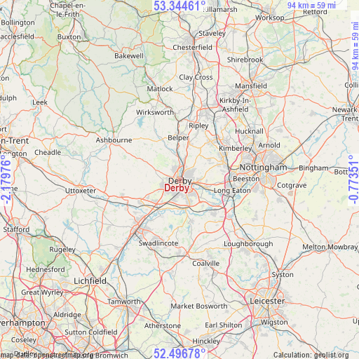
Derby GPS coordinates[2]
52° 55' 21.972" North, 1° 28' 35.868" West
| Map corner | latitude | longitude |
|---|---|---|
| Upper-left | 53.34461°, | -2.17976° |
| Center: | 52.92277°, | -1.47663° |
| Lower-right: | 52.49678°, | -0.77351° |
| Map W x H: | 94.3×94.3 km | = 58.6×58.6mi |
| max Lat: | 60.39635° ⇑40.6% North |
| Derby: | 52.92277° |
| min Lat: | ⇓59.4% South 34.60088° |
| min Long | Derby | max Long |
| -7.64133° | -1.47663° | 32.95536° |
| W 56%⇐ | ⇒44% E |
Elevation
Elevation of Derby is 55 m = 180 ft, and this is 17.9 m = 59 ft below average elevation for this country.
| Max E: |
515 m = 1690 ft | 53.7% |
| Avg. | 72.9 m = 239 ft | |
| Derby | 55 m = 180 ft | |
Min E: |
-30 m = -98 ft | 46.3% |
See also: Derby elevation on elevation.city.
Geographical zone
Derby is located in North temperate zone (between Tropic of Cancer and the Arctic Circle). Distance of this North polar circle is 1516.7 km =942.4 mi to North.| Distance of | km | miles | from Derby |
|---|---|---|---|
| North Pole | 4122.6 | 2561.7 | to North |
| Arctic Circle | 1516.7 | 942.4 | to North |
| Tropic Cancer | 3278.5 | 2037.2 | to South |
| Equator | 5884.5 | 3656.5 | to South |


Nearby cities:
15 places around Derby: (largest is in red/bold)
• Aston-on-Trent
9.1 km =5.7 mi,  138°
138°
• Belper
11.2 km =7 mi,  358°
358°
• Borrowash
6.5 km =4 mi,  106°
106°
• Brailsford
11.1 km =6.9 mi,  298°
298°
• Duffield
7.1 km =4.4 mi,  353°
353°
• Etwall
9.4 km =5.8 mi,  242°
242°
• Findern
7.4 km =4.6 mi,  217°
217°
• Kilburn
9.6 km =6 mi,  15°
15°
• Little Eaton
5.4 km =3.4 mi,  12°
12°
• Quarndon
5 km =3.1 mi,  338°
338°
• Repton
10.5 km =6.5 mi,  208°
208°
• Shardlow
9.7 km =6 mi,  127°
127°
• Sinfin
4.6 km =2.9 mi,  188°
188°
• West Hallam
9.6 km =6 mi,  55°
55°
• Weston upon Trent
9.7 km =6 mi,  148°
148°
Sources, notices
• [Note1] Compared only with cities in United Kingdom existing in our database
• [Src1] Map data: © OpenStreetMap contributors (CC-BY-SA)
• [Src2] Other city data from geonames.org with taken over terms of usage.
• [Src3] Geographical zone / Annual Mean Temperature by Robert A. Rohde @ Wikipedia
