Aston-on-Trent geodata
Aston-on-Trent (England) is a populated place; located in United Kingdom in Europe/London (GMT+1) time zone. With population of 2,160 people, there are 2527 cities with bigger population in this country. Compared to other cities in United Kingdom, 58.4% of cities are located further ↓South; 58% of cities are located further ←West and 62.4% of cities have higher elevation than Aston-on-Trent. Note1
Administrative division(s):
- Level 1: England
- Level 2: Derbyshire
- Level 3: South Derbyshire District
- Level 4: Aston upon Trent


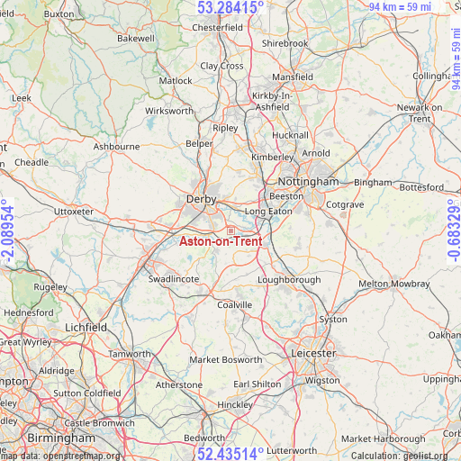
Aston-on-Trent GPS coordinates[2]
52° 51' 42.192" North, 1° 23' 11.112" West
| Map corner | latitude | longitude |
|---|---|---|
| Upper-left | 53.28415°, | -2.08954° |
| Center: | 52.86172°, | -1.38642° |
| Lower-right: | 52.43514°, | -0.68329° |
| Map W x H: | 94.4×94.4 km | = 58.7×58.7mi |
| max Lat: | 60.39635° ⇑41.6% North |
| Aston-on-Trent: | 52.86172° |
| min Lat: | ⇓58.4% South 34.60088° |
| min Long | Aston-on-Trent | max Long |
| -7.64133° | -1.38642° | 32.95536° |
| W 58%⇐ | ⇒42% E |
Elevation
Elevation of Aston-on-Trent is 43 m = 141 ft, and this is 29.9 m = 98 ft below average elevation for this country.
| Max E: |
515 m = 1690 ft | 62.4% |
| Avg. | 72.9 m = 239 ft | |
| Aston-on-Trent | 43 m = 141 ft | |
Min E: |
-30 m = -98 ft | 37.6% |
See also: United Kingdom elevation on elevation.city.
Geographical zone
Aston-on-Trent is located in North temperate zone (between Tropic of Cancer and the Arctic Circle). Distance of this North polar circle is 1523.5 km =946.7 mi to North.| Distance of | km | miles | from Aston-on-Trent |
|---|---|---|---|
| North Pole | 4129.4 | 2565.9 | to North |
| Arctic Circle | 1523.5 | 946.7 | to North |
| Tropic Cancer | 3271.8 | 2033 | to South |
| Equator | 5877.7 | 3652.2 | to South |


Nearby cities:
15 places around Aston-on-Trent: (largest is in red/bold)
• Belton
9.3 km =5.8 mi,  159°
159°
• Borrowash
5 km =3.1 mi,  1°
1°
• Breedon on the Hill
6.7 km =4.2 mi,  189°
189°
• Castle Donington
3.6 km =2.2 mi,  124°
124°
• Derby
9.1 km =5.7 mi,  318°
318°
• Diseworth
6.3 km =3.9 mi,  143°
143°
• Kegworth
7.7 km =4.8 mi,  112°
112°
• Long Eaton
8.7 km =5.4 mi,  62°
62°
• Long Whatton
9.2 km =5.7 mi,  132°
132°
• Melbourne
5.1 km =3.2 mi,  210°
210°
• Shardlow
1.8 km =1.1 mi, 61°
• Sinfin
7.1 km =4.4 mi,  288°
288°
• Sutton Bonington
10.2 km =6.3 mi, 115°
• Ticknall
8.3 km =5.2 mi,  227°
227°
• Weston upon Trent
1.8 km =1.1 mi, 213°
Sources, notices
• [Note1] Compared only with cities in United Kingdom existing in our database
• [Src1] Map data: © OpenStreetMap contributors (CC-BY-SA)
• [Src2] Other city data from geonames.org with taken over terms of usage.
• [Src3] Geographical zone / Annual Mean Temperature by Robert A. Rohde @ Wikipedia
