Darwen geodata
Darwen (England) is a populated place; located in United Kingdom in Europe/London (GMT+1) time zone. With population of 32,566 people, there are 376 cities with bigger population in this country. Compared to other cities in United Kingdom, 73.6% of cities are located further ↓South; 64.5% of cities are located further →East and 93.8% of cities have lower elevation than Darwen. Note1


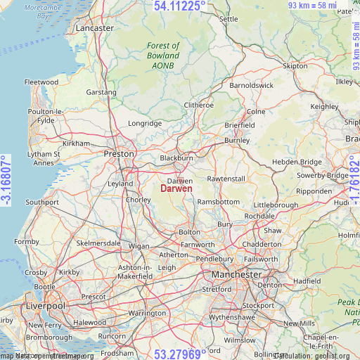
Darwen GPS coordinates[2]
53° 41' 52.908" North, 2° 27' 53.784" West
| Map corner | latitude | longitude |
|---|---|---|
| Upper-left | 54.11225°, | -3.16807° |
| Center: | 53.69803°, | -2.46494° |
| Lower-right: | 53.27969°, | -1.76182° |
| Map W x H: | 92.6×92.6 km | = 57.5×57.5mi |
| max Lat: | 60.39635° ⇑26.4% North |
| Darwen: | 53.69803° |
| min Lat: | ⇓73.6% South 34.60088° |
| min Long | Darwen | max Long |
| -7.64133° | -2.46494° | 32.95536° |
| W 35.5%⇐ | ⇒64.5% E |
Elevation
Elevation of Darwen is 172 m = 564 ft, and this is 99.1 m = 325 ft above average elevation for this country.
| Max E: |
515 m = 1690 ft | 6.2% |
| Darwen | 172 m 564 ft | |
| Avg. | 72.9 m = 239 ft | |
Min E: |
-30 m = -98 ft | 93.8% |
See also: United Kingdom elevation on elevation.city.
Geographical zone
Darwen is located in North temperate zone (between Tropic of Cancer and the Arctic Circle). Distance of this North polar circle is 1430.5 km =888.9 mi to North.| Distance of | km | miles | from Darwen |
|---|---|---|---|
| North Pole | 4036.4 | 2508.1 | to North |
| Arctic Circle | 1430.5 | 888.9 | to North |
| Tropic Cancer | 3364.7 | 2090.7 | to South |
| Equator | 5970.7 | 3710 | to South |


Nearby cities:
15 places around Darwen: (largest is in red/bold)
• Accrington
9.3 km =5.8 mi,  48°
48°
• Blackburn
5.9 km =3.7 mi,  348°
348°
• Brinscall
7.1 km =4.4 mi,  261°
261°
• Chorley
11.3 km =7 mi,  241°
241°
• Church
7.7 km =4.8 mi,  39°
39°
• Clayton le Moors
9.3 km =5.8 mi, 35°
• Edenfield
11.1 km =6.9 mi,  108°
108°
• Edgworth
7.4 km =4.6 mi,  140°
140°
• Great Harwood
10.4 km =6.5 mi,  20°
20°
• Haslingden
9.3 km =5.8 mi,  86°
86°
• Hoghton
9.1 km =5.7 mi,  296°
296°
• Langho
11.6 km =7.2 mi,  4°
4°
• Ramsbottom
11.2 km =7 mi,  119°
119°
• Rawtenstall
11.9 km =7.4 mi, 88°
• Rishton
8.5 km =5.3 mi, 23°
Sources, notices
• [Note1] Compared only with cities in United Kingdom existing in our database
• [Src1] Map data: © OpenStreetMap contributors (CC-BY-SA)
• [Src2] Other city data from geonames.org with taken over terms of usage.
• [Src3] Geographical zone / Annual Mean Temperature by Robert A. Rohde @ Wikipedia
