Blackburn geodata
Blackburn (England) is a seat of a second-order administrative division; located in United Kingdom in Europe/London (GMT+1) time zone. With population of 146,521 people, there are 64 cities with bigger population in this country. Compared to other cities in United Kingdom, 74.7% of cities are located further ↓South; 64.8% of cities are located further →East and 81.3% of cities have lower elevation than Blackburn. Note1


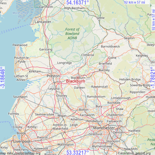
Blackburn GPS coordinates[2]
53° 45' 0" North, 2° 28' 59.988" West
| Map corner | latitude | longitude |
|---|---|---|
| Upper-left | 54.16371°, | -3.18646° |
| Center: | 53.75°, | -2.48333° |
| Lower-right: | 53.33217°, | -1.78021° |
| Map W x H: | 92.5×92.5 km | = 57.5×57.5mi |
| max Lat: | 60.39635° ⇑25.3% North |
| Blackburn: | 53.75° |
| min Lat: | ⇓74.7% South 34.60088° |
| min Long | Blackburn | max Long |
| -7.64133° | -2.48333° | 32.95536° |
| W 35.2%⇐ | ⇒64.8% E |
Elevation
Elevation of Blackburn is 121 m = 397 ft, and this is 48.1 m = 158 ft above average elevation for this country.
| Max E: |
515 m = 1690 ft | 18.7% |
| Blackburn | 121 m 397 ft | |
| Avg. | 72.9 m = 239 ft | |
Min E: |
-30 m = -98 ft | 81.3% |
See also: Blackburn elevation on elevation.city.
Geographical zone
Blackburn is located in North temperate zone (between Tropic of Cancer and the Arctic Circle). Distance of this North polar circle is 1424.7 km =885.3 mi to North.| Distance of | km | miles | from Blackburn |
|---|---|---|---|
| North Pole | 4030.6 | 2504.5 | to North |
| Arctic Circle | 1424.7 | 885.3 | to North |
| Tropic Cancer | 3370.5 | 2094.3 | to South |
| Equator | 5976.4 | 3713.6 | to South |


Nearby cities:
15 places around Blackburn: (largest is in red/bold)
• Accrington
8.2 km =5.1 mi,  87°
87°
• Billington
8.3 km =5.2 mi,  28°
28°
• Brinscall
8.9 km =5.5 mi,  220°
220°
• Church
6.1 km =3.8 mi, 88°
• Clayton le Moors
6.8 km =4.2 mi,  74°
74°
• Darwen
5.9 km =3.7 mi,  168°
168°
• Great Harwood
6.3 km =3.9 mi,  51°
51°
• Hapton
11.6 km =7.2 mi, 71°
• Haslingden
11.7 km =7.3 mi,  116°
116°
• Hoghton
7.1 km =4.4 mi,  256°
256°
• Langho
6.2 km =3.9 mi,  20°
20°
• Longridge
11.9 km =7.4 mi,  320°
320°
• Ribchester
7.8 km =4.8 mi,  335°
335°
• Rishton
5 km =3.1 mi, 66°
• Whalley
9.5 km =5.9 mi, 31°
Sources, notices
• [Note1] Compared only with cities in United Kingdom existing in our database
• [Src1] Map data: © OpenStreetMap contributors (CC-BY-SA)
• [Src2] Other city data from geonames.org with taken over terms of usage.
• [Src3] Geographical zone / Annual Mean Temperature by Robert A. Rohde @ Wikipedia
