Crail geodata
Crail (Scotland) is a populated place; located in United Kingdom in Europe/London (GMT+1) time zone. With population of 1,670 people, there are 2884 cities with bigger population in this country. Compared to other cities in United Kingdom, 95.9% of cities are located further ↓South; 67.4% of cities are located further →East and 70% of cities have higher elevation than Crail. Note1


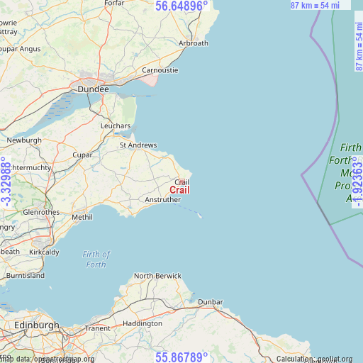
Crail GPS coordinates[2]
56° 15' 37.512" North, 2° 37' 36.336" West
| Map corner | latitude | longitude |
|---|---|---|
| Upper-left | 56.64896°, | -3.32988° |
| Center: | 56.26042°, | -2.62676° |
| Lower-right: | 55.86789°, | -1.92363° |
| Map W x H: | 86.8×86.8 km | = 53.9×53.9mi |
| max Lat: | 60.39635° ⇑4.1% North |
| Crail: | 56.26042° |
| min Lat: | ⇓95.9% South 34.60088° |
| min Long | Crail | max Long |
| -7.64133° | -2.62676° | 32.95536° |
| W 32.6%⇐ | ⇒67.4% E |
Elevation
Elevation of Crail is 33 m = 108 ft, and this is 39.9 m = 131 ft below average elevation for this country.
| Max E: |
515 m = 1690 ft | 70% |
| Avg. | 72.9 m = 239 ft | |
| Crail | 33 m = 108 ft | |
Min E: |
-30 m = -98 ft | 30% |
See also: United Kingdom elevation on elevation.city.
Geographical zone
Crail is located in North temperate zone (between Tropic of Cancer and the Arctic Circle). Distance of this North polar circle is 1145.6 km =711.8 mi to North.| Distance of | km | miles | from Crail |
|---|---|---|---|
| North Pole | 3751.5 | 2331.1 | to North |
| Arctic Circle | 1145.6 | 711.8 | to North |
| Tropic Cancer | 3649.7 | 2267.8 | to South |
| Equator | 6255.6 | 3887 | to South |


Nearby cities:
15 places around Crail: (largest is in red/bold)
• Anstruther
6.2 km =3.9 mi,  228°
228°
• Balmullo
22.7 km =14.1 mi,  304°
304°
• Ceres
21.7 km =13.5 mi,  279°
279°
• Cupar
24.6 km =15.3 mi,  285°
285°
• Elie
14.2 km =8.8 mi,  238°
238°
• Guardbridge
19.9 km =12.4 mi,  306°
306°
• Leuchars
20.8 km =12.9 mi, 310°
• Leven
24 km =14.9 mi,  253°
253°
• Lundin Links
20.9 km =13 mi,  255°
255°
• Methil
25.8 km =16 mi, 251°
• North Berwick
23.3 km =14.5 mi,  194°
194°
• Pittenweem
8.1 km =5 mi, 230°
• Saint Andrews
13.7 km =8.5 mi, 309°
• Saint Monans
10.6 km =6.6 mi, 235°
• Strathkinness
17.5 km =10.9 mi, 298°
Sources, notices
• [Note1] Compared only with cities in United Kingdom existing in our database
• [Src1] Map data: © OpenStreetMap contributors (CC-BY-SA)
• [Src2] Other city data from geonames.org with taken over terms of usage.
• [Src3] Geographical zone / Annual Mean Temperature by Robert A. Rohde @ Wikipedia
