Connor geodata
Connor (Northern Ireland) is a populated place; located in United Kingdom in Europe/London (GMT+1) time zone. With population of 1,778 people, there are 2791 cities with bigger population in this country. Compared to other cities in United Kingdom, 85% of cities are located further ↓South; 98.7% of cities are located further →East and 72.2% of cities have lower elevation than Connor. Note1


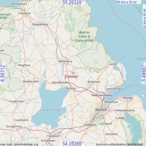
Connor GPS coordinates[2]
54° 48' 0" North, 6° 12' 0" West
| Map corner | latitude | longitude |
|---|---|---|
| Upper-left | 55.20328°, | -6.90312° |
| Center: | 54.8°, | -6.2° |
| Lower-right: | 54.39266°, | -5.49687° |
| Map W x H: | 90.1×90.1 km | = 56×56mi |
| max Lat: | 60.39635° ⇑15% North |
| Connor: | 54.8° |
| min Lat: | ⇓85% South 34.60088° |
| min Long | Connor | max Long |
| -7.64133° | -6.2° | 32.95536° |
| W 1.3%⇐ | ⇒98.7% E |
Elevation
Elevation of Connor is 100 m = 328 ft, and this is 27.1 m = 89 ft above average elevation for this country.
| Max E: |
515 m = 1690 ft | 27.8% |
| Connor | 100 m 328 ft | |
| Avg. | 72.9 m = 239 ft | |
Min E: |
-30 m = -98 ft | 72.2% |
See also: United Kingdom elevation on elevation.city.
Geographical zone
Connor is located in North temperate zone (between Tropic of Cancer and the Arctic Circle). Distance of this North polar circle is 1308 km =812.8 mi to North.| Distance of | km | miles | from Connor |
|---|---|---|---|
| North Pole | 3913.9 | 2432 | to North |
| Arctic Circle | 1308 | 812.8 | to North |
| Tropic Cancer | 3487.3 | 2166.9 | to South |
| Equator | 6093.2 | 3786.1 | to South |


Nearby cities:
15 places around Connor: (largest is in red/bold)
• Ahoghill
13 km =8.1 mi,  304°
304°
• Antrim
11.1 km =6.9 mi,  180°
180°
• Ballyclare
14 km =8.7 mi,  113°
113°
• Ballymena
8.6 km =5.3 mi,  325°
325°
• Bellaghy
20.5 km =12.7 mi,  272°
272°
• Broughshane
10.3 km =6.4 mi,  356°
356°
• Carnmoney
20.6 km =12.8 mi,  128°
128°
• Crumlin
20 km =12.4 mi, 182°
• Cullybackey
13.6 km =8.5 mi,  316°
316°
• Doagh
9.3 km =5.8 mi, 126°
• Glenavy
23.1 km =14.4 mi, 182°
• Jordanstown
23.2 km =14.4 mi,  123°
123°
• Portglenone
19.1 km =11.9 mi,  294°
294°
• Randalstown
8.5 km =5.3 mi,  229°
229°
• Templepatrick
15 km =9.3 mi,  150°
150°
Sources, notices
• [Note1] Compared only with cities in United Kingdom existing in our database
• [Src1] Map data: © OpenStreetMap contributors (CC-BY-SA)
• [Src2] Other city data from geonames.org with taken over terms of usage.
• [Src3] Geographical zone / Annual Mean Temperature by Robert A. Rohde @ Wikipedia
