Glenavy geodata
Glenavy (Northern Ireland) is a populated place; located in United Kingdom in Europe/London (GMT+1) time zone. With population of 1,089 people, there are 3517 cities with bigger population in this country. Compared to other cities in United Kingdom, 83.1% of cities are located further ↓South; 98.7% of cities are located further →East and 56.6% of cities have lower elevation than Glenavy. Note1


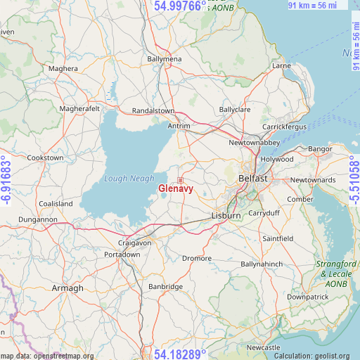
Glenavy GPS coordinates[2]
54° 35' 32.316" North, 6° 12' 49.356" West
| Map corner | latitude | longitude |
|---|---|---|
| Upper-left | 54.99766°, | -6.91683° |
| Center: | 54.59231°, | -6.21371° |
| Lower-right: | 54.18289°, | -5.51058° |
| Map W x H: | 90.6×90.6 km | = 56.3×56.3mi |
| max Lat: | 60.39635° ⇑16.9% North |
| Glenavy: | 54.59231° |
| min Lat: | ⇓83.1% South 34.60088° |
| min Long | Glenavy | max Long |
| -7.64133° | -6.21371° | 32.95536° |
| W 1.3%⇐ | ⇒98.7% E |
Elevation
Elevation of Glenavy is 71 m = 233 ft, and this is 1.9 m = 6 ft below average elevation for this country.
| Max E: |
515 m = 1690 ft | 43.4% |
| Avg. | 72.9 m = 239 ft | |
| Glenavy | 71 m = 233 ft | |
Min E: |
-30 m = -98 ft | 56.6% |
See also: United Kingdom elevation on elevation.city.
Geographical zone
Glenavy is located in North temperate zone (between Tropic of Cancer and the Arctic Circle). Distance of this North polar circle is 1331.1 km =827.1 mi to North.| Distance of | km | miles | from Glenavy |
|---|---|---|---|
| North Pole | 3937 | 2446.3 | to North |
| Arctic Circle | 1331.1 | 827.1 | to North |
| Tropic Cancer | 3464.2 | 2152.6 | to South |
| Equator | 6070.1 | 3771.8 | to South |


Nearby cities:
15 places around Glenavy: (largest is in red/bold)
• Antrim
12 km =7.5 mi,  4°
4°
• Belfast
18.6 km =11.6 mi,  88°
88°
• Carnmoney
19.8 km =12.3 mi,  59°
59°
• Castlereagh
21.3 km =13.2 mi,  95°
95°
• Craigavon
19.6 km =12.2 mi,  214°
214°
• Crumlin
3.1 km =1.9 mi,  359°
359°
• Doagh
19.4 km =12.1 mi,  25°
25°
• Hillsborough
16.8 km =10.4 mi,  148°
148°
• Lisburn
13.8 km =8.6 mi,  123°
123°
• Magheralin
14.3 km =8.9 mi,  192°
192°
• Moira
12.5 km =7.8 mi,  184°
184°
• Newtownabbey
21 km =13 mi,  69°
69°
• Randalstown
18.4 km =11.4 mi,  342°
342°
• Templepatrick
13.1 km =8.1 mi,  39°
39°
• Waringstown
18.4 km =11.4 mi,  197°
197°
Sources, notices
• [Note1] Compared only with cities in United Kingdom existing in our database
• [Src1] Map data: © OpenStreetMap contributors (CC-BY-SA)
• [Src2] Other city data from geonames.org with taken over terms of usage.
• [Src3] Geographical zone / Annual Mean Temperature by Robert A. Rohde @ Wikipedia
