Coningsby geodata
Coningsby (England) is a populated place; located in United Kingdom in Europe/London (GMT+1) time zone. With population of 4,388 people, there are 1757 cities with bigger population in this country. Compared to other cities in United Kingdom, 62.2% of cities are located further ↓South; 83.4% of cities are located further ←West and 92.6% of cities have higher elevation than Coningsby. Note1
Administrative division(s):
- Level 1: England
- Level 2: Lincolnshire
- Level 3: East Lindsey District
- Level 4: Coningsby


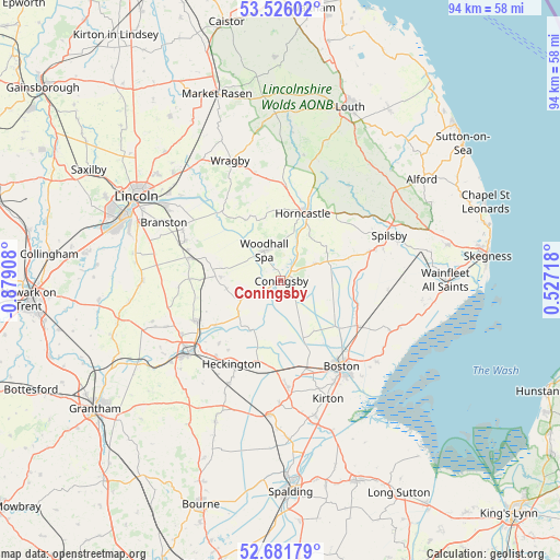
Coningsby GPS coordinates[2]
53° 6' 21.528" North, 0° 10' 33.42" West
| Map corner | latitude | longitude |
|---|---|---|
| Upper-left | 53.52602°, | -0.87908° |
| Center: | 53.10598°, | -0.17595° |
| Lower-right: | 52.68179°, | 0.52718° |
| Map W x H: | 93.9×93.9 km | = 58.3×58.3mi |
| max Lat: | 60.39635° ⇑37.8% North |
| Coningsby: | 53.10598° |
| min Lat: | ⇓62.2% South 34.60088° |
| min Long | Coningsby | max Long |
| -7.64133° | -0.17595° | 32.95536° |
| W 83.4%⇐ | ⇒16.6% E |
Elevation
Elevation of Coningsby is 10 m = 33 ft, and this is 62.9 m = 206 ft below average elevation for this country.
| Max E: |
515 m = 1690 ft | 92.6% |
| Avg. | 72.9 m = 239 ft | |
| Coningsby | 10 m = 33 ft | |
Min E: |
-30 m = -98 ft | 7.4% |
See also: United Kingdom elevation on elevation.city.
Geographical zone
Coningsby is located in North temperate zone (between Tropic of Cancer and the Arctic Circle). Distance of this North polar circle is 1496.3 km =929.8 mi to North.| Distance of | km | miles | from Coningsby |
|---|---|---|---|
| North Pole | 4102.2 | 2549 | to North |
| Arctic Circle | 1496.3 | 929.8 | to North |
| Tropic Cancer | 3298.9 | 2049.8 | to South |
| Equator | 5904.8 | 3669.1 | to South |


Nearby cities:
15 places around Coningsby: (largest is in red/bold)
• Bardney
15.2 km =9.4 mi,  319°
319°
• Billinghay
7.4 km =4.6 mi,  246°
246°
• Digby
14.7 km =9.1 mi,  258°
258°
• Ewerby
14.8 km =9.2 mi,  224°
224°
• Horncastle
12 km =7.5 mi,  19°
19°
• Mareham le Fen
6.4 km =4 mi,  63°
63°
• Martin
10.3 km =6.4 mi,  281°
281°
• Ruskington
15.6 km =9.7 mi,  244°
244°
• Scopwick
15.1 km =9.4 mi,  271°
271°
• Sibsey
14.8 km =9.2 mi,  120°
120°
• Stickney
12.2 km =7.6 mi,  98°
98°
• Thimbleby
12.1 km =7.5 mi,  10°
10°
• Timberland
10.2 km =6.3 mi, 273°
• Walcott
9.2 km =5.7 mi, 262°
• Woodhall Spa
5.7 km =3.5 mi,  333°
333°
Sources, notices
• [Note1] Compared only with cities in United Kingdom existing in our database
• [Src1] Map data: © OpenStreetMap contributors (CC-BY-SA)
• [Src2] Other city data from geonames.org with taken over terms of usage.
• [Src3] Geographical zone / Annual Mean Temperature by Robert A. Rohde @ Wikipedia
