Cherhill geodata
Cherhill (England) is a populated place; located in United Kingdom in Europe/London (GMT+1) time zone. With population of 572 people, there are 4666 cities with bigger population in this country. Compared to other cities in United Kingdom, 80% of cities are located further ↑North; 53.9% of cities are located further →East and 77.7% of cities have lower elevation than Cherhill. Note1


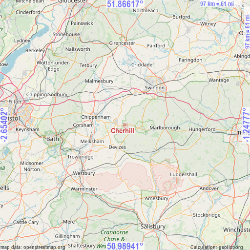
Cherhill GPS coordinates[2]
51° 25' 47.604" North, 1° 57' 3.24" West
| Map corner | latitude | longitude |
|---|---|---|
| Upper-left | 51.86617°, | -2.65402° |
| Center: | 51.42989°, | -1.9509° |
| Lower-right: | 50.98941°, | -1.24777° |
| Map W x H: | 97.5×97.5 km | = 60.6×60.6mi |
| max Lat: | 60.39635° ⇑80% North |
| Cherhill: | 51.42989° |
| min Lat: | ⇓20% South 34.60088° |
| min Long | Cherhill | max Long |
| -7.64133° | -1.9509° | 32.95536° |
| W 46.1%⇐ | ⇒53.9% E |
Elevation
Elevation of Cherhill is 112 m = 367 ft, and this is 39.1 m = 128 ft above average elevation for this country.
| Max E: |
515 m = 1690 ft | 22.3% |
| Cherhill | 112 m 367 ft | |
| Avg. | 72.9 m = 239 ft | |
Min E: |
-30 m = -98 ft | 77.7% |
See also: United Kingdom elevation on elevation.city.
Geographical zone
Cherhill is located in North temperate zone (between Tropic of Cancer and the Arctic Circle). Distance of this North polar circle is 1682.7 km =1045.6 mi to North.| Distance of | km | miles | from Cherhill |
|---|---|---|---|
| North Pole | 4288.6 | 2664.8 | to North |
| Arctic Circle | 1682.7 | 1045.6 | to North |
| Tropic Cancer | 3112.5 | 1934 | to South |
| Equator | 5718.5 | 3553.3 | to South |


Nearby cities:
15 places around Cherhill: (largest is in red/bold)
• Avebury
6 km =3.7 mi,  104°
104°
• Bremhill
6.3 km =3.9 mi,  298°
298°
• Broad Hinton
9.7 km =6 mi,  47°
47°
• Calne
3.9 km =2.4 mi,  284°
284°
• Chippenham
12.5 km =7.8 mi,  285°
285°
• Christian Malford
11.5 km =7.1 mi,  321°
321°
• Devizes
9.3 km =5.8 mi,  198°
198°
• Fyfield
11.7 km =7.3 mi, 97°
• Huish
12.8 km =8 mi,  120°
120°
• Lacock
12 km =7.5 mi,  262°
262°
• Lyneham
9.7 km =6 mi,  353°
353°
• Potterne
11.8 km =7.3 mi, 198°
• Rowde
9.3 km =5.8 mi,  216°
216°
• Sutton Benger
12.4 km =7.7 mi,  313°
313°
• Woodborough
12.8 km =8 mi,  142°
142°
Sources, notices
• [Note1] Compared only with cities in United Kingdom existing in our database
• [Src1] Map data: © OpenStreetMap contributors (CC-BY-SA)
• [Src2] Other city data from geonames.org with taken over terms of usage.
• [Src3] Geographical zone / Annual Mean Temperature by Robert A. Rohde @ Wikipedia
