Bremhill geodata
Bremhill (England) is a seat of a third-order administrative division; located in United Kingdom in Europe/London (GMT+1) time zone. In our database, there are 4977 cities with bigger population. Compared to other cities in United Kingdom, 79.1% of cities are located further ↑North; 55.4% of cities are located further →East and 72.7% of cities have lower elevation than Bremhill. Note1


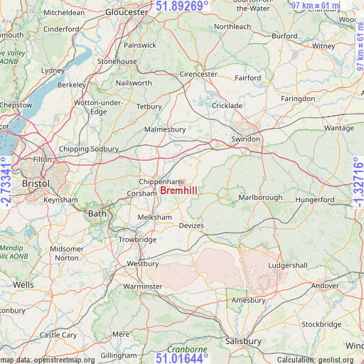
Bremhill GPS coordinates[2]
51° 27' 24.012" North, 2° 1' 49.008" West
| Map corner | latitude | longitude |
|---|---|---|
| Upper-left | 51.89269°, | -2.73341° |
| Center: | 51.45667°, | -2.03028° |
| Lower-right: | 51.01644°, | -1.32716° |
| Map W x H: | 97.4×97.4 km | = 60.5×60.5mi |
| max Lat: | 60.39635° ⇑79.1% North |
| Bremhill: | 51.45667° |
| min Lat: | ⇓20.9% South 34.60088° |
| min Long | Bremhill | max Long |
| -7.64133° | -2.03028° | 32.95536° |
| W 44.6%⇐ | ⇒55.4% E |
Elevation
Elevation of Bremhill is 101 m = 331 ft, and this is 28.1 m = 92 ft above average elevation for this country.
| Max E: |
515 m = 1690 ft | 27.3% |
| Bremhill | 101 m 331 ft | |
| Avg. | 72.9 m = 239 ft | |
Min E: |
-30 m = -98 ft | 72.7% |
See also: United Kingdom elevation on elevation.city.
Geographical zone
Bremhill is located in North temperate zone (between Tropic of Cancer and the Arctic Circle). Distance of this North polar circle is 1679.7 km =1043.7 mi to North.| Distance of | km | miles | from Bremhill |
|---|---|---|---|
| North Pole | 4285.6 | 2662.9 | to North |
| Arctic Circle | 1679.7 | 1043.7 | to North |
| Tropic Cancer | 3115.5 | 1935.9 | to South |
| Equator | 5721.4 | 3555.1 | to South |


Nearby cities:
15 places around Bremhill: (largest is in red/bold)
• Biddestone
11.7 km =7.3 mi,  272°
272°
• Calne
2.6 km =1.6 mi,  139°
139°
• Cherhill
6.3 km =3.9 mi,  118°
118°
• Chippenham
6.6 km =4.1 mi, 273°
• Christian Malford
6.2 km =3.9 mi,  343°
343°
• Corsham
11 km =6.8 mi,  256°
256°
• Devizes
12 km =7.5 mi,  167°
167°
• Great Somerford
9.8 km =6.1 mi,  351°
351°
• Kington Langley
7 km =4.3 mi,  300°
300°
• Lacock
7.8 km =4.8 mi,  234°
234°
• Lyneham
8 km =5 mi,  33°
33°
• Rowde
10.4 km =6.5 mi,  180°
180°
• Sutton Benger
6.6 km =4.1 mi,  328°
328°
• Whitley
11.5 km =7.1 mi, 233°
• Yatton Keynell
11.8 km =7.3 mi,  286°
286°
Sources, notices
• [Note1] Compared only with cities in United Kingdom existing in our database
• [Src1] Map data: © OpenStreetMap contributors (CC-BY-SA)
• [Src2] Other city data from geonames.org with taken over terms of usage.
• [Src3] Geographical zone / Annual Mean Temperature by Robert A. Rohde @ Wikipedia
