Chelsea geodata
Chelsea (England) is a section of populated place; located in United Kingdom in Europe/London (GMT+1) time zone. With population of 60,000 people, there are 185 cities with bigger population in this country. Compared to other cities in United Kingdom, 78.1% of cities are located further ↑North; 83.5% of cities are located further ←West and 89.9% of cities have higher elevation than Chelsea. Note1
Administrative division(s):
- Level 1: England
- Level 2: Greater London
- Level 3: Royal Kensington and Chelsea


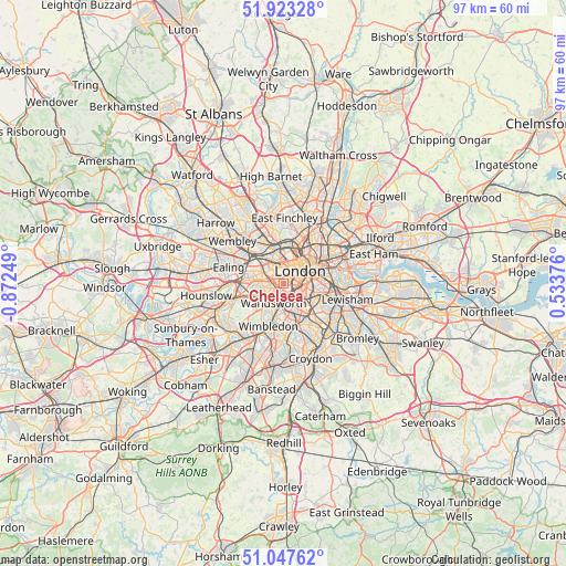
Chelsea GPS coordinates[2]
51° 29' 15.18" North, 0° 10' 9.696" West
| Map corner | latitude | longitude |
|---|---|---|
| Upper-left | 51.92328°, | -0.87249° |
| Center: | 51.48755°, | -0.16936° |
| Lower-right: | 51.04762°, | 0.53376° |
| Map W x H: | 97.4×97.4 km | = 60.5×60.5mi |
| max Lat: | 60.39635° ⇑78.1% North |
| Chelsea: | 51.48755° |
| min Lat: | ⇓21.9% South 34.60088° |
| min Long | Chelsea | max Long |
| -7.64133° | -0.16936° | 32.95536° |
| W 83.5%⇐ | ⇒16.5% E |
Elevation
Elevation of Chelsea is 12 m = 39 ft, and this is 60.9 m = 200 ft below average elevation for this country.
| Max E: |
515 m = 1690 ft | 89.9% |
| Avg. | 72.9 m = 239 ft | |
| Chelsea | 12 m = 39 ft | |
Min E: |
-30 m = -98 ft | 10.1% |
See also: Chelsea elevation on elevation.city.
Geographical zone
Chelsea is located in North temperate zone (between Tropic of Cancer and the Arctic Circle). Distance of this North polar circle is 1676.3 km =1041.6 mi to North.| Distance of | km | miles | from Chelsea |
|---|---|---|---|
| North Pole | 4282.2 | 2660.8 | to North |
| Arctic Circle | 1676.3 | 1041.6 | to North |
| Tropic Cancer | 3119 | 1938.1 | to South |
| Equator | 5724.9 | 3557.3 | to South |


Nearby cities:
15 places around Chelsea: (largest is in red/bold)
• Battersea
1.7 km =1.1 mi,  145°
145°
• Bayswater
2.8 km =1.7 mi,  338°
338°
• Brixton
5 km =3.1 mi,  118°
118°
• Brixton Hill
5.1 km =3.2 mi,  140°
140°
• Camberwell
5.4 km =3.4 mi,  106°
106°
• City of Westminster
2.6 km =1.6 mi,  64°
64°
• Clerkenwell
5.8 km =3.6 mi,  44°
44°
• Earlsfield
5 km =3.1 mi,  192°
192°
• Hammersmith
4.2 km =2.6 mi,  279°
279°
• Kennington
4.4 km =2.7 mi,  89°
89°
• Kensington
2.1 km =1.3 mi,  313°
313°
• Lambeth
4.1 km =2.5 mi,  76°
76°
• London
3.8 km =2.4 mi,  52°
52°
• Wandsworth
4.3 km =2.7 mi,  218°
218°
• West End of London
3.1 km =1.9 mi,  18°
18°
Sources, notices
• [Note1] Compared only with cities in United Kingdom existing in our database
• [Src1] Map data: © OpenStreetMap contributors (CC-BY-SA)
• [Src2] Other city data from geonames.org with taken over terms of usage.
• [Src3] Geographical zone / Annual Mean Temperature by Robert A. Rohde @ Wikipedia
