Battersea geodata
Battersea (England) is a section of populated place; located in United Kingdom in Europe/London (GMT+1) time zone. With population of 75,651 people, there are 136 cities with bigger population in this country. Compared to other cities in United Kingdom, 78.6% of cities are located further ↑North; 83.8% of cities are located further ←West and 96.2% of cities have higher elevation than Battersea. Note1


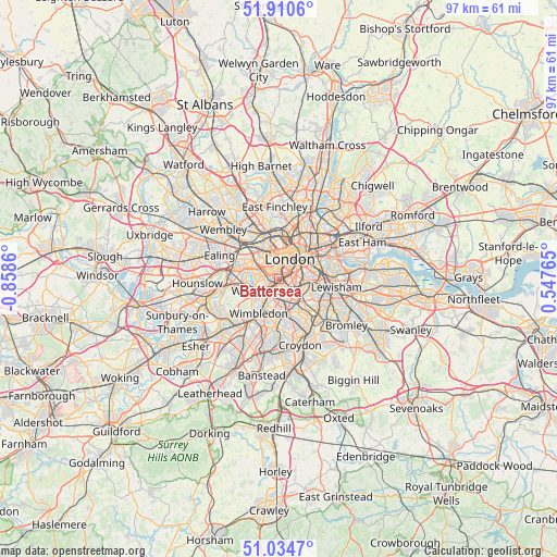
Battersea GPS coordinates[2]
51° 28' 29.1" North, 0° 9' 19.692" West
| Map corner | latitude | longitude |
|---|---|---|
| Upper-left | 51.9106°, | -0.8586° |
| Center: | 51.47475°, | -0.15547° |
| Lower-right: | 51.0347°, | 0.54765° |
| Map W x H: | 97.4×97.4 km | = 60.5×60.5mi |
| max Lat: | 60.39635° ⇑78.6% North |
| Battersea: | 51.47475° |
| min Lat: | ⇓21.4% South 34.60088° |
| min Long | Battersea | max Long |
| -7.64133° | -0.15547° | 32.95536° |
| W 83.8%⇐ | ⇒16.2% E |
Elevation
Elevation of Battersea is 7 m = 23 ft, and this is 65.9 m = 216 ft below average elevation for this country.
| Max E: |
515 m = 1690 ft | 96.2% |
| Avg. | 72.9 m = 239 ft | |
| Battersea | 7 m = 23 ft | |
Min E: |
-30 m = -98 ft | 3.8% |
See also: Battersea elevation on elevation.city.
Geographical zone
Battersea is located in North temperate zone (between Tropic of Cancer and the Arctic Circle). Distance of this North polar circle is 1677.7 km =1042.5 mi to North.| Distance of | km | miles | from Battersea |
|---|---|---|---|
| North Pole | 4283.6 | 2661.7 | to North |
| Arctic Circle | 1677.7 | 1042.5 | to North |
| Tropic Cancer | 3117.5 | 1937.1 | to South |
| Equator | 5723.5 | 3556.4 | to South |


Nearby cities:
15 places around Battersea: (largest is in red/bold)
• Bayswater
4.5 km =2.8 mi,  333°
333°
• Brixton
3.5 km =2.2 mi,  106°
106°
• Brixton Hill
3.4 km =2.1 mi,  138°
138°
• Camberwell
4.3 km =2.7 mi,  91°
91°
• Chelsea
1.7 km =1.1 mi, 325°
• City of Westminster
2.9 km =1.8 mi,  28°
28°
• Earlsfield
4 km =2.5 mi,  211°
211°
• Hammersmith
5.5 km =3.4 mi,  292°
292°
• Kennington
3.7 km =2.3 mi,  66°
66°
• Kensington
3.8 km =2.4 mi,  319°
319°
• Lambeth
3.9 km =2.4 mi,  51°
51°
• London
4.3 km =2.7 mi, 28°
• Peckham
5.9 km =3.7 mi, 90°
• Wandsworth
4.1 km =2.5 mi,  242°
242°
• West End of London
4.4 km =2.7 mi,  0°
0°
Sources, notices
• [Note1] Compared only with cities in United Kingdom existing in our database
• [Src1] Map data: © OpenStreetMap contributors (CC-BY-SA)
• [Src2] Other city data from geonames.org with taken over terms of usage.
• [Src3] Geographical zone / Annual Mean Temperature by Robert A. Rohde @ Wikipedia
