Cheadle geodata
Cheadle (England) is a populated place; located in United Kingdom in Europe/London (GMT+1) time zone. With population of 11,404 people, there are 952 cities with bigger population in this country. Compared to other cities in United Kingdom, 60.3% of cities are located further ↓South; 54.4% of cities are located further →East and 91.7% of cities have lower elevation than Cheadle. Note1
Administrative division(s):
- Level 1: England
- Level 2: Staffordshire
- Level 3: Staffordshire Moorlands
- Level 4: Cheadle


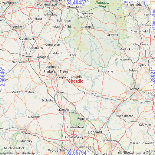
Cheadle GPS coordinates[2]
52° 58' 59.988" North, 1° 58' 59.988" West
| Map corner | latitude | longitude |
|---|---|---|
| Upper-left | 53.40457°, | -2.68646° |
| Center: | 52.98333°, | -1.98333° |
| Lower-right: | 52.55794°, | -1.28021° |
| Map W x H: | 94.1×94.1 km | = 58.5×58.5mi |
| max Lat: | 60.39635° ⇑39.7% North |
| Cheadle: | 52.98333° |
| min Lat: | ⇓60.3% South 34.60088° |
| min Long | Cheadle | max Long |
| -7.64133° | -1.98333° | 32.95536° |
| W 45.6%⇐ | ⇒54.4% E |
Elevation
Elevation of Cheadle is 159 m = 522 ft, and this is 86.1 m = 282 ft above average elevation for this country.
| Max E: |
515 m = 1690 ft | 8.3% |
| Cheadle | 159 m 522 ft | |
| Avg. | 72.9 m = 239 ft | |
Min E: |
-30 m = -98 ft | 91.7% |
See also: United Kingdom elevation on elevation.city.
Geographical zone
Cheadle is located in North temperate zone (between Tropic of Cancer and the Arctic Circle). Distance of this North polar circle is 1510 km =938.3 mi to North.| Distance of | km | miles | from Cheadle |
|---|---|---|---|
| North Pole | 4115.9 | 2557.5 | to North |
| Arctic Circle | 1510 | 938.3 | to North |
| Tropic Cancer | 3285.3 | 2041.4 | to South |
| Equator | 5891.2 | 3660.6 | to South |


Nearby cities:
15 places around Cheadle: (largest is in red/bold)
• Ashbourne
17.1 km =10.6 mi,  77°
77°
• Barlaston
13.4 km =8.3 mi,  249°
249°
• Bramshall
10.9 km =6.8 mi,  153°
153°
• Cheddleton
10.3 km =6.4 mi,  337°
337°
• Doveridge
13.7 km =8.5 mi,  129°
129°
• Fulford
7.8 km =4.8 mi,  229°
229°
• Ipstones
7.1 km =4.4 mi,  7°
7°
• Kingsley
3.7 km =2.3 mi,  0°
0°
• Leek
13.7 km =8.5 mi,  349°
349°
• Longton
10 km =6.2 mi,  270°
270°
• Mayfield
14.6 km =9.1 mi, 82°
• Newcastle under Lyme
16.8 km =10.4 mi,  276°
276°
• Stoke-on-Trent
13.7 km =8.5 mi, 279°
• Stone
14.3 km =8.9 mi, 233°
• Uttoxeter
12.3 km =7.6 mi,  139°
139°
Sources, notices
• [Note1] Compared only with cities in United Kingdom existing in our database
• [Src1] Map data: © OpenStreetMap contributors (CC-BY-SA)
• [Src2] Other city data from geonames.org with taken over terms of usage.
• [Src3] Geographical zone / Annual Mean Temperature by Robert A. Rohde @ Wikipedia
