Chard geodata
Chard (England) is a populated place; located in United Kingdom in Europe/London (GMT+1) time zone. With population of 13,074 people, there are 867 cities with bigger population in this country. Compared to other cities in United Kingdom, 93.8% of cities are located further ↑North; 74.5% of cities are located further →East and 80.2% of cities have lower elevation than Chard. Note1
Administrative division(s):
- Level 1: England
- Level 2: Somerset
- Level 3: South Somerset District
- Level 4: Chard Town


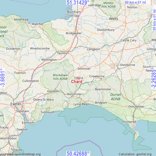
Chard GPS coordinates[2]
50° 52' 21.72" North, 2° 57' 57.492" West
| Map corner | latitude | longitude |
|---|---|---|
| Upper-left | 51.31429°, | -3.6691° |
| Center: | 50.8727°, | -2.96597° |
| Lower-right: | 50.42688°, | -2.26285° |
| Map W x H: | 98.7×98.7 km | = 61.3×61.3mi |
| max Lat: | 60.39635° ⇑93.8% North |
| Chard: | 50.8727° |
| min Lat: | ⇓6.2% South 34.60088° |
| min Long | Chard | max Long |
| -7.64133° | -2.96597° | 32.95536° |
| W 25.5%⇐ | ⇒74.5% E |
Elevation
Elevation of Chard is 118 m = 387 ft, and this is 45.1 m = 148 ft above average elevation for this country.
| Max E: |
515 m = 1690 ft | 19.8% |
| Chard | 118 m 387 ft | |
| Avg. | 72.9 m = 239 ft | |
Min E: |
-30 m = -98 ft | 80.2% |
See also: United Kingdom elevation on elevation.city.
Geographical zone
Chard is located in North temperate zone (between Tropic of Cancer and the Arctic Circle). Distance of this North polar circle is 1744.7 km =1084.1 mi to North.| Distance of | km | miles | from Chard |
|---|---|---|---|
| North Pole | 4350.5 | 2703.3 | to North |
| Arctic Circle | 1744.7 | 1084.1 | to North |
| Tropic Cancer | 3050.6 | 1895.6 | to South |
| Equator | 5656.5 | 3514.8 | to South |


Nearby cities:
15 places around Chard: (largest is in red/bold)
• Axminster
10.3 km =6.4 mi,  192°
192°
• Broadwindsor
13 km =8.1 mi,  116°
116°
• Crewkerne
12 km =7.5 mi,  84°
84°
• Fivehead
14.7 km =9.1 mi,  12°
12°
• Haselbury Plucknett
15.2 km =9.4 mi, 80°
• Ilminster
7.2 km =4.5 mi,  33°
33°
• Ilton
9.5 km =5.9 mi,  17°
17°
• Kilmington
11.7 km =7.3 mi,  206°
206°
• Merriott
12.8 km =8 mi,  69°
69°
• Mosterton
13.9 km =8.6 mi,  103°
103°
• Musbury
14.7 km =9.1 mi,  198°
198°
• Raymond's Hill
12.3 km =7.6 mi,  180°
180°
• South Petherton
14 km =8.7 mi,  52°
52°
• West Chinnock
15.4 km =9.6 mi, 70°
• Winsham
5.8 km =3.6 mi,  111°
111°
Sources, notices
• [Note1] Compared only with cities in United Kingdom existing in our database
• [Src1] Map data: © OpenStreetMap contributors (CC-BY-SA)
• [Src2] Other city data from geonames.org with taken over terms of usage.
• [Src3] Geographical zone / Annual Mean Temperature by Robert A. Rohde @ Wikipedia
