Raymond's Hill geodata
Raymond's Hill (England) is a populated place; located in United Kingdom in Europe/London (GMT+1) time zone. With population of 768 people, there are 4103 cities with bigger population in this country. Compared to other cities in United Kingdom, 95.8% of cities are located further ↑North; 74.6% of cities are located further →East and 95.1% of cities have lower elevation than Raymond's Hill. Note1
Administrative division(s):
- Level 1: England
- Level 2: Devon
- Level 3: East Devon District
- Level 4: Axminster


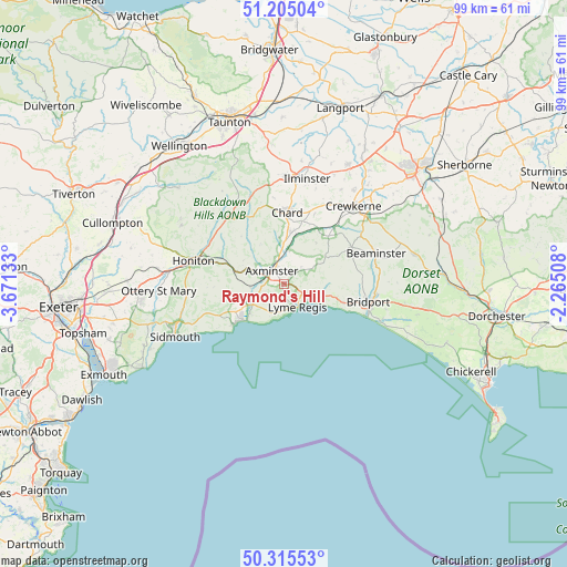
Raymond's Hill GPS coordinates[2]
50° 45' 44.64" North, 2° 58' 5.52" West
| Map corner | latitude | longitude |
|---|---|---|
| Upper-left | 51.20504°, | -3.67133° |
| Center: | 50.7624°, | -2.9682° |
| Lower-right: | 50.31553°, | -2.26508° |
| Map W x H: | 98.9×98.9 km | = 61.5×61.5mi |
| max Lat: | 60.39635° ⇑95.8% North |
| Raymond's Hill: | 50.7624° |
| min Lat: | ⇓4.2% South 34.60088° |
| min Long | Raymond's Hill | max Long |
| -7.64133° | -2.9682° | 32.95536° |
| W 25.4%⇐ | ⇒74.6% E |
Elevation
Elevation of Raymond's Hill is 186 m = 610 ft, and this is 113.1 m = 371 ft above average elevation for this country.
| Max E: |
515 m = 1690 ft | 4.9% |
| Raymond's Hill | 186 m 610 ft | |
| Avg. | 72.9 m = 239 ft | |
Min E: |
-30 m = -98 ft | 95.1% |
See also: United Kingdom elevation on elevation.city.
Geographical zone
Raymond's Hill is located in North temperate zone (between Tropic of Cancer and the Arctic Circle). Distance of this North polar circle is 1756.9 km =1091.7 mi to North.| Distance of | km | miles | from Raymond's Hill |
|---|---|---|---|
| North Pole | 4362.8 | 2710.9 | to North |
| Arctic Circle | 1756.9 | 1091.7 | to North |
| Tropic Cancer | 3038.3 | 1887.9 | to South |
| Equator | 5644.2 | 3507.1 | to South |


Nearby cities:
15 places around Raymond's Hill: (largest is in red/bold)
• Axminster
3.1 km =1.9 mi,  317°
317°
• Beaminster
16.9 km =10.5 mi,  72°
72°
• Bridport
15.1 km =9.4 mi,  102°
102°
• Broadwindsor
13.4 km =8.3 mi,  61°
61°
• Chard
12.3 km =7.6 mi,  0°
0°
• Charmouth
5.4 km =3.4 mi,  118°
118°
• Chideock
11 km =6.8 mi,  107°
107°
• Colyton
7.6 km =4.7 mi,  250°
250°
• Crewkerne
18.1 km =11.2 mi,  42°
42°
• Honiton
16.1 km =10 mi,  284°
284°
• Kilmington
5.3 km =3.3 mi,  289°
289°
• Lyme Regis
4.6 km =2.9 mi,  149°
149°
• Mosterton
16.5 km =10.3 mi, 56°
• Musbury
4.8 km =3 mi, 249°
• Winsham
11.6 km =7.2 mi,  28°
28°
Sources, notices
• [Note1] Compared only with cities in United Kingdom existing in our database
• [Src1] Map data: © OpenStreetMap contributors (CC-BY-SA)
• [Src2] Other city data from geonames.org with taken over terms of usage.
• [Src3] Geographical zone / Annual Mean Temperature by Robert A. Rohde @ Wikipedia
