Cerne Abbas geodata
Cerne Abbas (England) is a populated place; located in United Kingdom in Europe/London (GMT+1) time zone. With population of 784 people, there are 4052 cities with bigger population in this country. Compared to other cities in United Kingdom, 95.1% of cities are located further ↑North; 64.6% of cities are located further →East and 81.3% of cities have lower elevation than Cerne Abbas. Note1
Administrative division(s):
- Level 1: England
- Level 2: Dorset
- Level 3: West Dorset District
- Level 4: Cerne Abbas


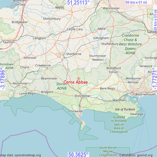
Cerne Abbas GPS coordinates[2]
50° 48' 32.148" North, 2° 28' 32.988" West
| Map corner | latitude | longitude |
|---|---|---|
| Upper-left | 51.25113°, | -3.17896° |
| Center: | 50.80893°, | -2.47583° |
| Lower-right: | 50.3625°, | -1.77271° |
| Map W x H: | 98.8×98.8 km | = 61.4×61.4mi |
| max Lat: | 60.39635° ⇑95.1% North |
| Cerne Abbas: | 50.80893° |
| min Lat: | ⇓4.9% South 34.60088° |
| min Long | Cerne Abbas | max Long |
| -7.64133° | -2.47583° | 32.95536° |
| W 35.4%⇐ | ⇒64.6% E |
Elevation
Elevation of Cerne Abbas is 121 m = 397 ft, and this is 48.1 m = 158 ft above average elevation for this country.
| Max E: |
515 m = 1690 ft | 18.7% |
| Cerne Abbas | 121 m 397 ft | |
| Avg. | 72.9 m = 239 ft | |
Min E: |
-30 m = -98 ft | 81.3% |
See also: United Kingdom elevation on elevation.city.
Geographical zone
Cerne Abbas is located in North temperate zone (between Tropic of Cancer and the Arctic Circle). Distance of this North polar circle is 1751.8 km =1088.5 mi to North.| Distance of | km | miles | from Cerne Abbas |
|---|---|---|---|
| North Pole | 4357.6 | 2707.7 | to North |
| Arctic Circle | 1751.8 | 1088.5 | to North |
| Tropic Cancer | 3043.5 | 1891.1 | to South |
| Equator | 5649.4 | 3510.4 | to South |


Nearby cities:
15 places around Cerne Abbas: (largest is in red/bold)
• Bradford Abbas
15.2 km =9.4 mi,  329°
329°
• Charminster
8.6 km =5.3 mi,  167°
167°
• Dorchester
10.7 km =6.6 mi,  163°
163°
• Halstock
14.2 km =8.8 mi,  297°
297°
• Maiden Newton
7.5 km =4.7 mi,  243°
243°
• Milborne Port
17.5 km =10.9 mi,  3°
3°
• Milborne St Andrew
14.1 km =8.8 mi,  103°
103°
• Oborne
17.5 km =10.9 mi,  356°
356°
• Portesham
16.6 km =10.3 mi,  201°
201°
• Puddletown
11 km =6.8 mi,  126°
126°
• Sherborne
15.5 km =9.6 mi,  349°
349°
• Sturminster Newton
17.8 km =11.1 mi,  42°
42°
• Winterborne Stickland
17.2 km =10.7 mi,  78°
78°
• Winterbourne Abbas
11.6 km =7.2 mi, 204°
• Yetminster
12.1 km =7.5 mi,  322°
322°
Sources, notices
• [Note1] Compared only with cities in United Kingdom existing in our database
• [Src1] Map data: © OpenStreetMap contributors (CC-BY-SA)
• [Src2] Other city data from geonames.org with taken over terms of usage.
• [Src3] Geographical zone / Annual Mean Temperature by Robert A. Rohde @ Wikipedia
