Puddletown geodata
Puddletown (England) is a populated place; located in United Kingdom in Europe/London (GMT+1) time zone. With population of 1,158 people, there are 3419 cities with bigger population in this country. Compared to other cities in United Kingdom, 96% of cities are located further ↑North; 62.3% of cities are located further →East and 51.2% of cities have higher elevation than Puddletown. Note1
Administrative division(s):
- Level 1: England
- Level 2: Dorset
- Level 3: West Dorset District
- Level 4: Puddletown


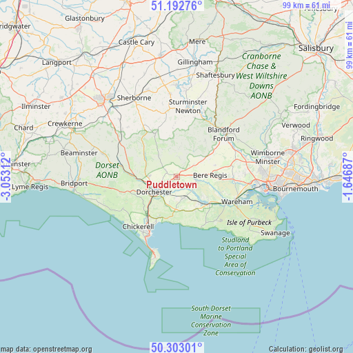
Puddletown GPS coordinates[2]
50° 45' 0" North, 2° 21' 0" West
| Map corner | latitude | longitude |
|---|---|---|
| Upper-left | 51.19276°, | -3.05312° |
| Center: | 50.75°, | -2.35° |
| Lower-right: | 50.30301°, | -1.64687° |
| Map W x H: | 98.9×98.9 km | = 61.5×61.5mi |
| max Lat: | 60.39635° ⇑96% North |
| Puddletown: | 50.75° |
| min Lat: | ⇓4% South 34.60088° |
| min Long | Puddletown | max Long |
| -7.64133° | -2.35° | 32.95536° |
| W 37.7%⇐ | ⇒62.3% E |
Elevation
Elevation of Puddletown is 59 m = 194 ft, and this is 13.9 m = 46 ft below average elevation for this country.
| Max E: |
515 m = 1690 ft | 51.2% |
| Avg. | 72.9 m = 239 ft | |
| Puddletown | 59 m = 194 ft | |
Min E: |
-30 m = -98 ft | 48.8% |
See also: United Kingdom elevation on elevation.city.
Geographical zone
Puddletown is located in North temperate zone (between Tropic of Cancer and the Arctic Circle). Distance of this North polar circle is 1758.3 km =1092.6 mi to North.| Distance of | km | miles | from Puddletown |
|---|---|---|---|
| North Pole | 4364.2 | 2711.8 | to North |
| Arctic Circle | 1758.3 | 1092.6 | to North |
| Tropic Cancer | 3037 | 1887.1 | to South |
| Equator | 5642.9 | 3506.3 | to South |


Nearby cities:
15 places around Puddletown: (largest is in red/bold)
• Bere Regis
9.5 km =5.9 mi,  87°
87°
• Bovington Camp
10 km =6.2 mi,  125°
125°
• Cerne Abbas
11 km =6.8 mi,  306°
306°
• Charlton Marshall
17.4 km =10.8 mi,  56°
56°
• Charminster
7.3 km =4.5 mi,  255°
255°
• Dorchester
6.9 km =4.3 mi,  237°
237°
• Maiden Newton
16 km =9.9 mi,  281°
281°
• Milborne St Andrew
5.8 km =3.6 mi, 56°
• Overcombe
14 km =8.7 mi,  204°
204°
• Portesham
17.5 km =10.9 mi, 239°
• Weymouth
16.9 km =10.5 mi,  207°
207°
• Winterborne Kingston
11.2 km =7 mi,  73°
73°
• Winterborne Stickland
12.9 km =8 mi,  38°
38°
• Winterbourne Abbas
14.3 km =8.9 mi,  253°
253°
• Wool
12.1 km =7.5 mi, 130°
Sources, notices
• [Note1] Compared only with cities in United Kingdom existing in our database
• [Src1] Map data: © OpenStreetMap contributors (CC-BY-SA)
• [Src2] Other city data from geonames.org with taken over terms of usage.
• [Src3] Geographical zone / Annual Mean Temperature by Robert A. Rohde @ Wikipedia
