Catsfield geodata
Catsfield (England) is a populated place; located in United Kingdom in Europe/London (GMT+1) time zone. With population of 639 people, there are 4466 cities with bigger population in this country. Compared to other cities in United Kingdom, 93.4% of cities are located further ↑North; 91.9% of cities are located further ←West and 56.8% of cities have higher elevation than Catsfield. Note1
Administrative division(s):
- Level 1: England
- Level 2: East Sussex
- Level 3: Rother District
- Level 4: Catsfield


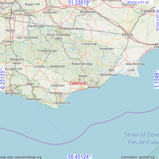
Catsfield GPS coordinates[2]
50° 53' 48.588" North, 0° 27' 6.372" East
| Map corner | latitude | longitude |
|---|---|---|
| Upper-left | 51.33819°, | -0.25135° |
| Center: | 50.89683°, | 0.45177° |
| Lower-right: | 50.45124°, | 1.1549° |
| Map W x H: | 98.6×98.6 km | = 61.3×61.3mi |
| max Lat: | 60.39635° ⇑93.4% North |
| Catsfield: | 50.89683° |
| min Lat: | ⇓6.6% South 34.60088° |
| min Long | Catsfield | max Long |
| -7.64133° | 0.45177° | 32.95536° |
| W 91.9%⇐ | ⇒8.1% E |
Elevation
Elevation of Catsfield is 51 m = 167 ft, and this is 21.9 m = 72 ft below average elevation for this country.
| Max E: |
515 m = 1690 ft | 56.8% |
| Avg. | 72.9 m = 239 ft | |
| Catsfield | 51 m = 167 ft | |
Min E: |
-30 m = -98 ft | 43.2% |
See also: United Kingdom elevation on elevation.city.
Geographical zone
Catsfield is located in North temperate zone (between Tropic of Cancer and the Arctic Circle). Distance of this North polar circle is 1742 km =1082.4 mi to North.| Distance of | km | miles | from Catsfield |
|---|---|---|---|
| North Pole | 4347.9 | 2701.7 | to North |
| Arctic Circle | 1742 | 1082.4 | to North |
| Tropic Cancer | 3053.3 | 1897.2 | to South |
| Equator | 5659.2 | 3516.5 | to South |


Nearby cities:
15 places around Catsfield: (largest is in red/bold)
• Battle
3.2 km =2 mi,  44°
44°
• Bexhill-on-Sea
5.4 km =3.4 mi,  165°
165°
• Bodle Street
7.8 km =4.8 mi,  283°
283°
• Burwash
12.1 km =7.5 mi,  337°
337°
• Burwash Common
12.5 km =7.8 mi,  321°
321°
• Crowhurst
3.3 km =2.1 mi,  112°
112°
• Hastings
9.7 km =6 mi,  118°
118°
• Herstmonceux
9.1 km =5.7 mi,  264°
264°
• Ninfield
2.2 km =1.4 mi,  238°
238°
• Pevensey
11.6 km =7.2 mi,  222°
222°
• Pevensey Bay
11.9 km =7.4 mi, 217°
• Robertsbridge
10 km =6.2 mi,  8°
8°
• Saint Leonards-on-Sea
8 km =5 mi, 124°
• Sedlescombe
7.1 km =4.4 mi,  54°
54°
• Staplecross
10.4 km =6.5 mi,  34°
34°
Sources, notices
• [Note1] Compared only with cities in United Kingdom existing in our database
• [Src1] Map data: © OpenStreetMap contributors (CC-BY-SA)
• [Src2] Other city data from geonames.org with taken over terms of usage.
• [Src3] Geographical zone / Annual Mean Temperature by Robert A. Rohde @ Wikipedia
