Bexhill-on-Sea geodata
Bexhill-on-Sea (England) is a populated place; located in United Kingdom in Europe/London (GMT+1) time zone. With population of 40,478 people, there are 301 cities with bigger population in this country. Compared to other cities in United Kingdom, 94.3% of cities are located further ↑North; 92% of cities are located further ←West and 85.8% of cities have higher elevation than Bexhill-on-Sea. Note1


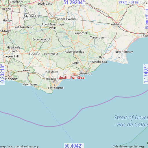
Bexhill-on-Sea GPS coordinates[2]
50° 51' 0.828" North, 0° 28' 15.42" East
| Map corner | latitude | longitude |
|---|---|---|
| Upper-left | 51.29204°, | -0.23218° |
| Center: | 50.85023°, | 0.47095° |
| Lower-right: | 50.4042°, | 1.17407° |
| Map W x H: | 98.7×98.7 km | = 61.3×61.3mi |
| max Lat: | 60.39635° ⇑94.3% North |
| Bexhill-on-Sea: | 50.85023° |
| min Lat: | ⇓5.7% South 34.60088° |
| min Long | Bexhill-on-Sea | max Long |
| -7.64133° | 0.47095° | 32.95536° |
| W 92%⇐ | ⇒8% E |
Elevation
Elevation of Bexhill-on-Sea is 15 m = 49 ft, and this is 57.9 m = 190 ft below average elevation for this country.
| Max E: |
515 m = 1690 ft | 85.8% |
| Avg. | 72.9 m = 239 ft | |
| Bexhill-on-Sea | 15 m = 49 ft | |
Min E: |
-30 m = -98 ft | 14.2% |
See also: Bexhill-on-Sea elevation on elevation.city.
Geographical zone
Bexhill-on-Sea is located in North temperate zone (between Tropic of Cancer and the Arctic Circle). Distance of this North polar circle is 1747.2 km =1085.7 mi to North.| Distance of | km | miles | from Bexhill-on-Sea |
|---|---|---|---|
| North Pole | 4353 | 2704.8 | to North |
| Arctic Circle | 1747.2 | 1085.7 | to North |
| Tropic Cancer | 3048.1 | 1894 | to South |
| Equator | 5654 | 3513.2 | to South |


Nearby cities:
15 places around Bexhill-on-Sea: (largest is in red/bold)
• Battle
7.5 km =4.7 mi,  7°
7°
• Bodle Street
11.4 km =7.1 mi,  307°
307°
• Catsfield
5.4 km =3.4 mi,  345°
345°
• Crowhurst
4.3 km =2.7 mi,  23°
23°
• Fairlight
13.4 km =8.3 mi,  76°
76°
• Hailsham
15 km =9.3 mi,  275°
275°
• Hastings
7.2 km =4.5 mi,  85°
85°
• Herstmonceux
11.3 km =7 mi,  292°
292°
• Ninfield
5.1 km =3.2 mi,  321°
321°
• Pevensey
9.8 km =6.1 mi,  249°
249°
• Pevensey Bay
9.6 km =6 mi,  243°
243°
• Robertsbridge
15.1 km =9.4 mi,  0°
0°
• Saint Leonards-on-Sea
5.2 km =3.2 mi, 83°
• Sedlescombe
10.3 km =6.4 mi,  25°
25°
• Staplecross
14.4 km =8.9 mi, 18°
Sources, notices
• [Note1] Compared only with cities in United Kingdom existing in our database
• [Src1] Map data: © OpenStreetMap contributors (CC-BY-SA)
• [Src2] Other city data from geonames.org with taken over terms of usage.
• [Src3] Geographical zone / Annual Mean Temperature by Robert A. Rohde @ Wikipedia
