Canterbury geodata
Canterbury (England) is a populated place; located in United Kingdom in Europe/London (GMT+1) time zone. With population of 55,240 people, there are 208 cities with bigger population in this country. Compared to other cities in United Kingdom, 84.8% of cities are located further ↑North; 96.9% of cities are located further ←West and 82% of cities have higher elevation than Canterbury. Note1


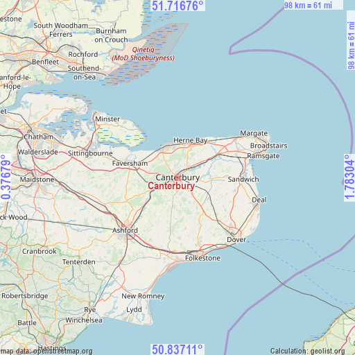
Canterbury GPS coordinates[2]
51° 16' 44.544" North, 1° 4' 47.712" East
| Map corner | latitude | longitude |
|---|---|---|
| Upper-left | 51.71676°, | 0.37679° |
| Center: | 51.27904°, | 1.07992° |
| Lower-right: | 50.83711°, | 1.78304° |
| Map W x H: | 97.8×97.8 km | = 60.8×60.8mi |
| max Lat: | 60.39635° ⇑84.8% North |
| Canterbury: | 51.27904° |
| min Lat: | ⇓15.2% South 34.60088° |
| min Long | Canterbury | max Long |
| -7.64133° | 1.07992° | 32.95536° |
| W 96.9%⇐ | ⇒3.1% E |
Elevation
Elevation of Canterbury is 19 m = 62 ft, and this is 53.9 m = 177 ft below average elevation for this country.
| Max E: |
515 m = 1690 ft | 82% |
| Avg. | 72.9 m = 239 ft | |
| Canterbury | 19 m = 62 ft | |
Min E: |
-30 m = -98 ft | 18% |
See also: Canterbury elevation on elevation.city.
Geographical zone
Canterbury is located in North temperate zone (between Tropic of Cancer and the Arctic Circle). Distance of this North polar circle is 1699.5 km =1056 mi to North.| Distance of | km | miles | from Canterbury |
|---|---|---|---|
| North Pole | 4305.4 | 2675.3 | to North |
| Arctic Circle | 1699.5 | 1056 | to North |
| Tropic Cancer | 3095.8 | 1923.6 | to South |
| Equator | 5701.7 | 3542.9 | to South |


Nearby cities:
15 places around Canterbury: (largest is in red/bold)
• Ash
13.9 km =8.6 mi,  90°
90°
• Aylesham
10.4 km =6.5 mi,  125°
125°
• Barham
9.8 km =6.1 mi,  146°
146°
• Blean
4 km =2.5 mi,  320°
320°
• Bridge
5 km =3.1 mi,  139°
139°
• Chartham
5 km =3.1 mi,  239°
239°
• Faversham
13.9 km =8.6 mi,  286°
286°
• Herne Bay
11 km =6.8 mi,  17°
17°
• Littlebourne
6.1 km =3.8 mi, 94°
• Sturry
3.8 km =2.4 mi,  49°
49°
• Tankerton
9.7 km =6 mi,  347°
347°
• Upstreet
9.5 km =5.9 mi,  56°
56°
• Whitstable
9.8 km =6.1 mi,  337°
337°
• Wingham
9.4 km =5.8 mi, 94°
• Wootton
13.6 km =8.5 mi, 149°
Sources, notices
• [Note1] Compared only with cities in United Kingdom existing in our database
• [Src1] Map data: © OpenStreetMap contributors (CC-BY-SA)
• [Src2] Other city data from geonames.org with taken over terms of usage.
• [Src3] Geographical zone / Annual Mean Temperature by Robert A. Rohde @ Wikipedia
