Faversham geodata
Faversham (England) is a populated place; located in United Kingdom in Europe/London (GMT+1) time zone. With population of 19,829 people, there are 606 cities with bigger population in this country. Compared to other cities in United Kingdom, 83.8% of cities are located further ↑North; 95.6% of cities are located further ←West and 91.2% of cities have higher elevation than Faversham. Note1
Administrative division(s):
- Level 1: England
- Level 2: Kent
- Level 3: Swale District
- Level 4: Faversham


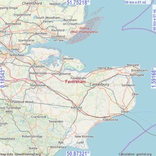
Faversham GPS coordinates[2]
51° 18' 53.28" North, 0° 53' 18.816" East
| Map corner | latitude | longitude |
|---|---|---|
| Upper-left | 51.75218°, | 0.18543° |
| Center: | 51.3148°, | 0.88856° |
| Lower-right: | 50.87321°, | 1.59168° |
| Map W x H: | 97.7×97.7 km | = 60.7×60.7mi |
| max Lat: | 60.39635° ⇑83.8% North |
| Faversham: | 51.3148° |
| min Lat: | ⇓16.2% South 34.60088° |
| min Long | Faversham | max Long |
| -7.64133° | 0.88856° | 32.95536° |
| W 95.6%⇐ | ⇒4.4% E |
Elevation
Elevation of Faversham is 11 m = 36 ft, and this is 61.9 m = 203 ft below average elevation for this country.
| Max E: |
515 m = 1690 ft | 91.2% |
| Avg. | 72.9 m = 239 ft | |
| Faversham | 11 m = 36 ft | |
Min E: |
-30 m = -98 ft | 8.8% |
See also: United Kingdom elevation on elevation.city.
Geographical zone
Faversham is located in North temperate zone (between Tropic of Cancer and the Arctic Circle). Distance of this North polar circle is 1695.5 km =1053.5 mi to North.| Distance of | km | miles | from Faversham |
|---|---|---|---|
| North Pole | 4301.4 | 2672.8 | to North |
| Arctic Circle | 1695.5 | 1053.5 | to North |
| Tropic Cancer | 3099.8 | 1926.1 | to South |
| Equator | 5705.7 | 3545.4 | to South |


Nearby cities:
15 places around Faversham: (largest is in red/bold)
• Blean
10.8 km =6.7 mi,  94°
94°
• Borden
13.3 km =8.3 mi,  279°
279°
• Canterbury
13.9 km =8.6 mi,  106°
106°
• Charing
13.3 km =8.3 mi,  209°
209°
• Chartham
11.1 km =6.9 mi,  125°
125°
• Eastchurch
10.4 km =6.5 mi,  348°
348°
• Iwade
13.1 km =8.1 mi,  302°
302°
• Lenham
14.6 km =9.1 mi,  233°
233°
• Leysdown-on-Sea
9.5 km =5.9 mi,  14°
14°
• Lynsted
7.1 km =4.4 mi,  267°
267°
• Sittingbourne
11.2 km =7 mi,  285°
285°
• Tankerton
12.4 km =7.7 mi,  64°
64°
• Teynham
6 km =3.7 mi, 286°
• Whitstable
10.8 km =6.7 mi, 61°
• Wye
15.1 km =9.4 mi,  167°
167°
Sources, notices
• [Note1] Compared only with cities in United Kingdom existing in our database
• [Src1] Map data: © OpenStreetMap contributors (CC-BY-SA)
• [Src2] Other city data from geonames.org with taken over terms of usage.
• [Src3] Geographical zone / Annual Mean Temperature by Robert A. Rohde @ Wikipedia
