Caister-on-Sea geodata
Caister-on-Sea (England) is a populated place; located in United Kingdom in Europe/London (GMT+0) time zone. With population of 8,901 people, there are 1150 cities with bigger population in this country. Compared to other cities in United Kingdom, 53.8% of cities are located further ↓South; 99.9% of cities are located further ←West and 99.8% of cities have higher elevation than Caister-on-Sea. Note1
Administrative division(s):
- Level 1: England
- Level 2: Norfolk
- Level 3: Great Yarmouth District
- Level 4: Caister-on-Sea


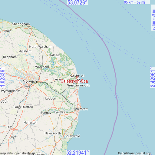
Caister-on-Sea GPS coordinates[2]
52° 38' 53.124" North, 1° 43' 35.328" East
| Map corner | latitude | longitude |
|---|---|---|
| Upper-left | 53.0726°, | 1.02336° |
| Center: | 52.64809°, | 1.72648° |
| Lower-right: | 52.21941°, | 2.42961° |
| Map W x H: | 94.9×94.9 km | = 59×59mi |
| max Lat: | 60.39635° ⇑46.2% North |
| Caister-on-Sea: | 52.64809° |
| min Lat: | ⇓53.8% South 34.60088° |
| min Long | Caister-on-Sea | max Long |
| -7.64133° | 1.72648° | 32.95536° |
| W 99.9%⇐ | ⇒0.099999999999994% E |
Elevation
Elevation of Caister-on-Sea is 2 m = 7 ft, and this is 70.9 m = 233 ft below average elevation for this country.
| Max E: |
515 m = 1690 ft | 99.8% |
| Avg. | 72.9 m = 239 ft | |
| Caister-on-Sea | 2 m = 7 ft | |
Min E: |
-30 m = -98 ft | 0.2% |
See also: United Kingdom elevation on elevation.city.
Geographical zone
Caister-on-Sea is located in North temperate zone (between Tropic of Cancer and the Arctic Circle). Distance of this North polar circle is 1547.3 km =961.4 mi to North.| Distance of | km | miles | from Caister-on-Sea |
|---|---|---|---|
| North Pole | 4153.1 | 2580.6 | to North |
| Arctic Circle | 1547.3 | 961.4 | to North |
| Tropic Cancer | 3248 | 2018.2 | to South |
| Equator | 5853.9 | 3637.4 | to South |


Nearby cities:
15 places around Caister-on-Sea: (largest is in red/bold)
• Acle
12.1 km =7.5 mi,  264°
264°
• Bradwell
8.5 km =5.3 mi,  192°
192°
• Filby
5.8 km =3.6 mi,  282°
282°
• Freethorpe
13.1 km =8.1 mi,  241°
241°
• Gorleston-on-Sea
8.4 km =5.2 mi,  178°
178°
• Great Yarmouth
4.4 km =2.7 mi, 176°
• Halvergate
11.2 km =7 mi,  245°
245°
• Hemsby
5.9 km =3.7 mi,  336°
336°
• Hopton on Sea
12.8 km =8 mi, 177°
• Martham
8.7 km =5.4 mi,  315°
315°
• Ormesby St Margaret
3.9 km =2.4 mi, 319°
• Potter Heigham
12.8 km =8 mi,  307°
307°
• Reedham
14.3 km =8.9 mi,  227°
227°
• Rollesby
7.4 km =4.6 mi,  302°
302°
• Upton
12.3 km =7.6 mi, 275°
Sources, notices
• [Note1] Compared only with cities in United Kingdom existing in our database
• [Src1] Map data: © OpenStreetMap contributors (CC-BY-SA)
• [Src2] Other city data from geonames.org with taken over terms of usage.
• [Src3] Geographical zone / Annual Mean Temperature by Robert A. Rohde @ Wikipedia
