Burton Bradstock geodata
Burton Bradstock (England) is a populated place; located in United Kingdom in Europe/London (GMT+1) time zone. With population of 682 people, there are 4319 cities with bigger population in this country. Compared to other cities in United Kingdom, 96.5% of cities are located further ↑North; 69.3% of cities are located further →East and 99% of cities have higher elevation than Burton Bradstock. Note1
Administrative division(s):
- Level 1: England
- Level 2: Dorset
- Level 3: West Dorset District
- Level 4: Burton Bradstock


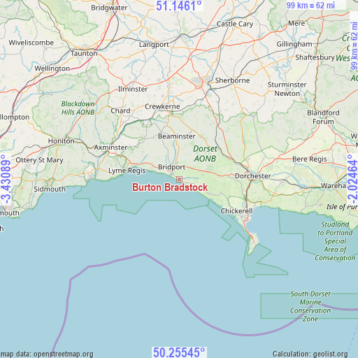
Burton Bradstock GPS coordinates[2]
50° 42' 10.404" North, 2° 43' 39.972" West
| Map corner | latitude | longitude |
|---|---|---|
| Upper-left | 51.1461°, | -3.43089° |
| Center: | 50.70289°, | -2.72777° |
| Lower-right: | 50.25545°, | -2.02464° |
| Map W x H: | 99×99 km | = 61.5×61.5mi |
| max Lat: | 60.39635° ⇑96.5% North |
| Burton Bradstock: | 50.70289° |
| min Lat: | ⇓3.5% South 34.60088° |
| min Long | Burton Bradstoc | max Long |
| -7.64133° | -2.72777° | 32.95536° |
| W 30.7%⇐ | ⇒69.3% E |
Elevation
Elevation of Burton Bradstock is 4 m = 13 ft, and this is 68.9 m = 226 ft below average elevation for this country.
| Max E: |
515 m = 1690 ft | 99% |
| Avg. | 72.9 m = 239 ft | |
| Burton Bradstock | 4 m = 13 ft | |
Min E: |
-30 m = -98 ft | 1% |
See also: United Kingdom elevation on elevation.city.
Geographical zone
Burton Bradstock is located in North temperate zone (between Tropic of Cancer and the Arctic Circle). Distance of this North polar circle is 1763.5 km =1095.8 mi to North.| Distance of | km | miles | from Burton Bradstock |
|---|---|---|---|
| North Pole | 4369.4 | 2715 | to North |
| Arctic Circle | 1763.5 | 1095.8 | to North |
| Tropic Cancer | 3031.7 | 1883.8 | to South |
| Equator | 5637.6 | 3503 | to South |


Nearby cities:
15 places around Burton Bradstock: (largest is in red/bold)
• Beaminster
11.8 km =7.3 mi,  356°
356°
• Bridport
4.1 km =2.5 mi,  327°
327°
• Broadwindsor
14 km =8.7 mi,  338°
338°
• Charminster
19.8 km =12.3 mi,  80°
80°
• Charmouth
12.8 km =8 mi,  288°
288°
• Chickerell
18.1 km =11.2 mi,  118°
118°
• Chideock
7.2 km =4.5 mi,  296°
296°
• Halstock
19.1 km =11.9 mi,  15°
15°
• Lyme Regis
14.8 km =9.2 mi,  280°
280°
• Maiden Newton
13.8 km =8.6 mi,  52°
52°
• Mosterton
16.1 km =10 mi,  348°
348°
• Portesham
12.1 km =7.5 mi,  107°
107°
• Raymond's Hill
18.2 km =11.3 mi, 291°
• Winsham
20.2 km =12.6 mi, 325°
• Winterbourne Abbas
13 km =8.1 mi, 84°
Sources, notices
• [Note1] Compared only with cities in United Kingdom existing in our database
• [Src1] Map data: © OpenStreetMap contributors (CC-BY-SA)
• [Src2] Other city data from geonames.org with taken over terms of usage.
• [Src3] Geographical zone / Annual Mean Temperature by Robert A. Rohde @ Wikipedia
