Burnley geodata
Burnley (England) is a seat of a fourth-order administrative division; located in United Kingdom in Europe/London (GMT+1) time zone. With population of 149,422 people, there are 60 cities with bigger population in this country. Compared to other cities in United Kingdom, 75.7% of cities are located further ↓South; 59.9% of cities are located further →East and 87.3% of cities have lower elevation than Burnley. Note1


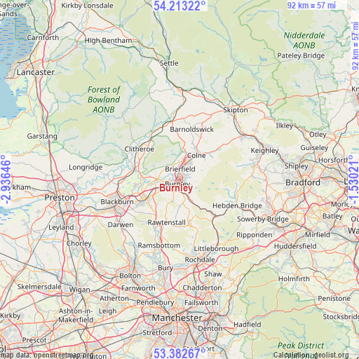
Burnley GPS coordinates[2]
53° 48' 0" North, 2° 13' 59.988" West
| Map corner | latitude | longitude |
|---|---|---|
| Upper-left | 54.21322°, | -2.93646° |
| Center: | 53.8°, | -2.23333° |
| Lower-right: | 53.38267°, | -1.53021° |
| Map W x H: | 92.3×92.3 km | = 57.4×57.4mi |
| max Lat: | 60.39635° ⇑24.3% North |
| Burnley: | 53.8° |
| min Lat: | ⇓75.7% South 34.60088° |
| min Long | Burnley | max Long |
| -7.64133° | -2.23333° | 32.95536° |
| W 40.1%⇐ | ⇒59.9% E |
Elevation
Elevation of Burnley is 140 m = 459 ft, and this is 67.1 m = 220 ft above average elevation for this country.
| Max E: |
515 m = 1690 ft | 12.7% |
| Burnley | 140 m 459 ft | |
| Avg. | 72.9 m = 239 ft | |
Min E: |
-30 m = -98 ft | 87.3% |
See also: Burnley elevation on elevation.city.
Geographical zone
Burnley is located in North temperate zone (between Tropic of Cancer and the Arctic Circle). Distance of this North polar circle is 1419.2 km =881.8 mi to North.| Distance of | km | miles | from Burnley |
|---|---|---|---|
| North Pole | 4025.1 | 2501.1 | to North |
| Arctic Circle | 1419.2 | 881.8 | to North |
| Tropic Cancer | 3376.1 | 2097.8 | to South |
| Equator | 5982 | 3717 | to South |


Nearby cities:
15 places around Burnley: (largest is in red/bold)
• Accrington
9.7 km =6 mi,  238°
238°
• Bacup
11 km =6.8 mi,  168°
168°
• Barrowford
5.3 km =3.3 mi,  10°
10°
• Brierfield
2.7 km =1.7 mi,  358°
358°
• Clayton le Moors
10.5 km =6.5 mi,  249°
249°
• Colne
7.6 km =4.7 mi,  33°
33°
• Cornholme
9.8 km =6.1 mi,  140°
140°
• Foulridge
9.4 km =5.8 mi, 26°
• Great Harwood
11.6 km =7.2 mi,  261°
261°
• Hameldon Hill
6.3 km =3.9 mi,  217°
217°
• Hapton
5.8 km =3.6 mi, 251°
• Nelson
4.3 km =2.7 mi, 30°
• Padiham
5.4 km =3.4 mi,  272°
272°
• Rawtenstall
11.5 km =7.1 mi,  196°
196°
• Sabden
7.8 km =4.8 mi,  298°
298°
Sources, notices
• [Note1] Compared only with cities in United Kingdom existing in our database
• [Src1] Map data: © OpenStreetMap contributors (CC-BY-SA)
• [Src2] Other city data from geonames.org with taken over terms of usage.
• [Src3] Geographical zone / Annual Mean Temperature by Robert A. Rohde @ Wikipedia
