Cornholme geodata
Cornholme (England) is a populated place; located in United Kingdom in Europe/London (GMT+1) time zone. With population of 1,690 people, there are 2867 cities with bigger population in this country. Compared to other cities in United Kingdom, 74.5% of cities are located further ↓South; 57.7% of cities are located further →East and 95.6% of cities have lower elevation than Cornholme. Note1


Cornholme GPS coordinates[2]
53° 43' 56.28" North, 2° 8' 18.636" West
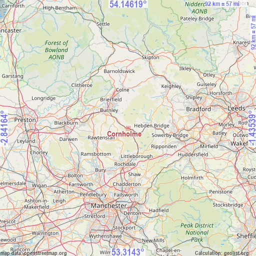
| Map corner | latitude | longitude |
|---|---|---|
| Upper-left | 54.14619°, | -2.84164° |
| Center: | 53.7323°, | -2.13851° |
| Lower-right: | 53.3143°, | -1.43539° |
| Map W x H: | 92.5×92.5 km | = 57.5×57.5mi |
| max Lat: | 60.39635° ⇑25.5% North |
| Cornholme: | 53.7323° |
| min Lat: | ⇓74.5% South 34.60088° |
| min Long | Cornholme | max Long |
| -7.64133° | -2.13851° | 32.95536° |
| W 42.3%⇐ | ⇒57.7% E |
Elevation
Elevation of Cornholme is 190 m = 623 ft, and this is 117.1 m = 384 ft above average elevation for this country.
| Max E: |
515 m = 1690 ft | 4.4% |
| Cornholme | 190 m 623 ft | |
| Avg. | 72.9 m = 239 ft | |
Min E: |
-30 m = -98 ft | 95.6% |
See also: United Kingdom elevation on elevation.city.
Geographical zone
Cornholme is located in North temperate zone (between Tropic of Cancer and the Arctic Circle). Distance of this North polar circle is 1426.7 km =886.5 mi to North.| Distance of | km | miles | from Cornholme |
|---|---|---|---|
| North Pole | 4032.6 | 2505.7 | to North |
| Arctic Circle | 1426.7 | 886.5 | to North |
| Tropic Cancer | 3368.6 | 2093.2 | to South |
| Equator | 5974.5 | 3712.4 | to South |


Nearby cities:
15 places around Cornholme: (largest is in red/bold)
• Bacup
5.2 km =3.2 mi,  231°
231°
• Brierfield
12 km =7.5 mi,  328°
328°
• Burnley
9.8 km =6.1 mi,  320°
320°
• Cragg vale
9.6 km =6 mi,  107°
107°
• Hameldon Hill
10.4 km =6.5 mi,  284°
284°
• Hebden Bridge
8.3 km =5.2 mi,  83°
83°
• Littleborough
10.2 km =6.3 mi,  163°
163°
• Mytholmroyd
10.3 km =6.4 mi,  91°
91°
• Nelson
11.9 km =7.4 mi,  340°
340°
• Rawtenstall
10.2 km =6.3 mi,  249°
249°
• Rossendale
10.5 km =6.5 mi,  239°
239°
• Todmorden
3.4 km =2.1 mi,  126°
126°
• Walsden
5 km =3.1 mi,  149°
149°
• Wardle
9.2 km =5.7 mi,  177°
177°
• Whitworth
8.9 km =5.5 mi,  196°
196°
Sources, notices
• [Note1] Compared only with cities in United Kingdom existing in our database
• [Src1] Map data: © OpenStreetMap contributors (CC-BY-SA)
• [Src2] Other city data from geonames.org with taken over terms of usage.
• [Src3] Geographical zone / Annual Mean Temperature by Robert A. Rohde @ Wikipedia
