Burnham-on-Crouch geodata
Burnham-on-Crouch (England) is a populated place; located in United Kingdom in Europe/London (GMT+1) time zone. With population of 7,561 people, there are 1275 cities with bigger population in this country. Compared to other cities in United Kingdom, 73.3% of cities are located further ↑North; 95.1% of cities are located further ←West and 84.7% of cities have higher elevation than Burnham-on-Crouch. Note1
Administrative division(s):
- Level 1: England
- Level 2: Essex
- Level 3: Maldon District
- Level 4: Burnham-on-Crouch


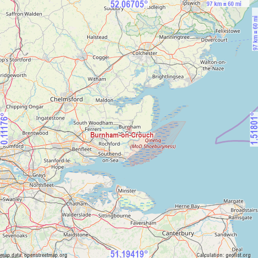
Burnham-on-Crouch GPS coordinates[2]
51° 37' 57.792" North, 0° 48' 53.568" East
| Map corner | latitude | longitude |
|---|---|---|
| Upper-left | 52.06705°, | 0.11176° |
| Center: | 51.63272°, | 0.81488° |
| Lower-right: | 51.19419°, | 1.51801° |
| Map W x H: | 97.1×97.1 km | = 60.3×60.3mi |
| max Lat: | 60.39635° ⇑73.3% North |
| Burnham-on-Crouch: | 51.63272° |
| min Lat: | ⇓26.7% South 34.60088° |
| min Long | Burnham-on-Crou | max Long |
| -7.64133° | 0.81488° | 32.95536° |
| W 95.1%⇐ | ⇒4.9% E |
Elevation
Elevation of Burnham-on-Crouch is 16 m = 52 ft, and this is 56.9 m = 187 ft below average elevation for this country.
| Max E: |
515 m = 1690 ft | 84.7% |
| Avg. | 72.9 m = 239 ft | |
| Burnham-on-Crouch | 16 m = 52 ft | |
Min E: |
-30 m = -98 ft | 15.3% |
See also: United Kingdom elevation on elevation.city.
Geographical zone
Burnham-on-Crouch is located in North temperate zone (between Tropic of Cancer and the Arctic Circle). Distance of this North polar circle is 1660.2 km =1031.6 mi to North.| Distance of | km | miles | from Burnham-on-Crouch |
|---|---|---|---|
| North Pole | 4266 | 2650.8 | to North |
| Arctic Circle | 1660.2 | 1031.6 | to North |
| Tropic Cancer | 3135.1 | 1948.1 | to South |
| Equator | 5741 | 3567.3 | to South |


Nearby cities:
15 places around Burnham-on-Crouch: (largest is in red/bold)
• Althorne
4.6 km =2.9 mi,  306°
306°
• Canewdon
5.1 km =3.2 mi,  250°
250°
• Cold Norton
10.9 km =6.8 mi,  293°
293°
• Goldhanger
13.6 km =8.5 mi,  341°
341°
• Great Wakering
9 km =5.6 mi,  184°
184°
• Latchingdon and Snoreham
7.5 km =4.7 mi, 305°
• Mayland
6.2 km =3.9 mi,  328°
328°
• North Fambridge
9.7 km =6 mi,  276°
276°
• Purleigh
12.4 km =7.7 mi,  299°
299°
• Rochford
9.4 km =5.8 mi,  232°
232°
• Southchurch Village
11.8 km =7.3 mi,  209°
209°
• Southend-on-Sea
12.6 km =7.8 mi, 213°
• Southminster
3.4 km =2.1 mi,  17°
17°
• Tillingham
8.5 km =5.3 mi,  33°
33°
• Westcliff-on-Sea
13 km =8.1 mi,  220°
220°
Sources, notices
• [Note1] Compared only with cities in United Kingdom existing in our database
• [Src1] Map data: © OpenStreetMap contributors (CC-BY-SA)
• [Src2] Other city data from geonames.org with taken over terms of usage.
• [Src3] Geographical zone / Annual Mean Temperature by Robert A. Rohde @ Wikipedia
