Buntingford geodata
Buntingford (England) is a populated place; located in United Kingdom in Europe/London (GMT+1) time zone. With population of 4,948 people, there are 1645 cities with bigger population in this country. Compared to other cities in United Kingdom, 63.8% of cities are located further ↑North; 86.2% of cities are located further ←West and 68.6% of cities have lower elevation than Buntingford. Note1
Administrative division(s):
- Level 1: England
- Level 2: Hertfordshire
- Level 3: East Hertfordshire District
- Level 4: Buntingford


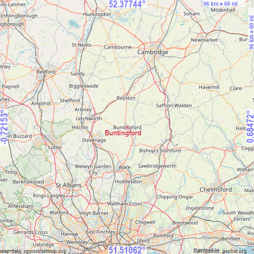
Buntingford GPS coordinates[2]
51° 56' 46.032" North, 0° 1' 6.276" West
| Map corner | latitude | longitude |
|---|---|---|
| Upper-left | 52.37744°, | -0.72153° |
| Center: | 51.94612°, | -0.01841° |
| Lower-right: | 51.51062°, | 0.68472° |
| Map W x H: | 96.4×96.4 km | = 59.9×59.9mi |
| max Lat: | 60.39635° ⇑63.8% North |
| Buntingford: | 51.94612° |
| min Lat: | ⇓36.2% South 34.60088° |
| min Long | Buntingford | max Long |
| -7.64133° | -0.01841° | 32.95536° |
| W 86.2%⇐ | ⇒13.8% E |
Elevation
Elevation of Buntingford is 93 m = 305 ft, and this is 20.1 m = 66 ft above average elevation for this country.
| Max E: |
515 m = 1690 ft | 31.4% |
| Buntingford | 93 m 305 ft | |
| Avg. | 72.9 m = 239 ft | |
Min E: |
-30 m = -98 ft | 68.6% |
See also: United Kingdom elevation on elevation.city.
Geographical zone
Buntingford is located in North temperate zone (between Tropic of Cancer and the Arctic Circle). Distance of this North polar circle is 1625.3 km =1009.9 mi to North.| Distance of | km | miles | from Buntingford |
|---|---|---|---|
| North Pole | 4231.2 | 2629.1 | to North |
| Arctic Circle | 1625.3 | 1009.9 | to North |
| Tropic Cancer | 3169.9 | 1969.7 | to South |
| Equator | 5775.9 | 3589 | to South |


Nearby cities:
15 places around Buntingford: (largest is in red/bold)
• Baldock
12.5 km =7.8 mi,  291°
291°
• Barkway
6.6 km =4.1 mi,  20°
20°
• Barley
9.7 km =6 mi, 23°
• Benington
8.4 km =5.2 mi,  228°
228°
• Braughing
5.4 km =3.4 mi,  143°
143°
• Clavering
11.3 km =7 mi,  79°
79°
• Furneux Pelham
7 km =4.3 mi,  103°
103°
• Great Chishill
11.2 km =7 mi,  33°
33°
• Great Munden
5.4 km =3.4 mi,  195°
195°
• Much Hadham
12 km =7.5 mi,  148°
148°
• Puckeridge
6.6 km =4.1 mi,  160°
160°
• Royston
11.4 km =7.1 mi,  357°
357°
• Thundridge
12.3 km =7.6 mi,  185°
185°
• Walkern
8.1 km =5 mi,  247°
247°
• Watton at Stone
11.7 km =7.3 mi,  213°
213°
Sources, notices
• [Note1] Compared only with cities in United Kingdom existing in our database
• [Src1] Map data: © OpenStreetMap contributors (CC-BY-SA)
• [Src2] Other city data from geonames.org with taken over terms of usage.
• [Src3] Geographical zone / Annual Mean Temperature by Robert A. Rohde @ Wikipedia
