Barkway geodata
Barkway (England) is a populated place; located in United Kingdom in Europe/London (GMT+1) time zone. With population of 775 people, there are 4085 cities with bigger population in this country. Compared to other cities in United Kingdom, 62% of cities are located further ↑North; 86.7% of cities are located further ←West and 84.2% of cities have lower elevation than Barkway. Note1
Administrative division(s):
- Level 1: England
- Level 2: Hertfordshire
- Level 3: North Hertfordshire District
- Level 4: Barkway


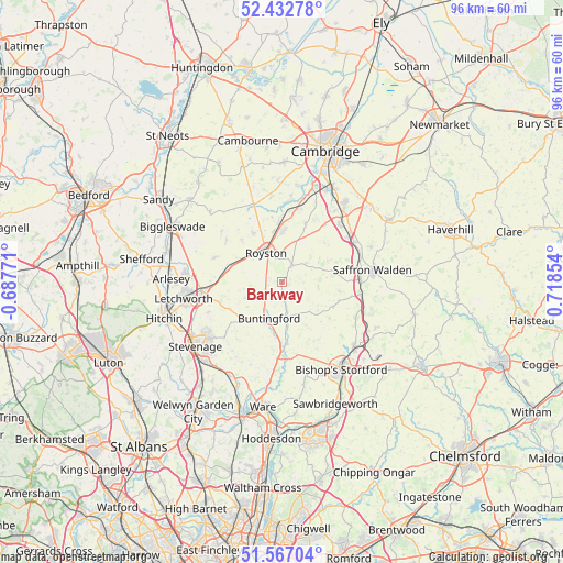
Barkway GPS coordinates[2]
52° 0' 7.2" North, 0° 0' 55.476" East
| Map corner | latitude | longitude |
|---|---|---|
| Upper-left | 52.43278°, | -0.68771° |
| Center: | 52.002°, | 0.01541° |
| Lower-right: | 51.56704°, | 0.71854° |
| Map W x H: | 96.3×96.3 km | = 59.8×59.8mi |
| max Lat: | 60.39635° ⇑62% North |
| Barkway: | 52.002° |
| min Lat: | ⇓38% South 34.60088° |
| min Long | Barkway | max Long |
| -7.64133° | 0.01541° | 32.95536° |
| W 86.7%⇐ | ⇒13.3% E |
Elevation
Elevation of Barkway is 130 m = 427 ft, and this is 57.1 m = 187 ft above average elevation for this country.
| Max E: |
515 m = 1690 ft | 15.8% |
| Barkway | 130 m 427 ft | |
| Avg. | 72.9 m = 239 ft | |
Min E: |
-30 m = -98 ft | 84.2% |
See also: United Kingdom elevation on elevation.city.
Geographical zone
Barkway is located in North temperate zone (between Tropic of Cancer and the Arctic Circle). Distance of this North polar circle is 1619.1 km =1006.1 mi to North.| Distance of | km | miles | from Barkway |
|---|---|---|---|
| North Pole | 4225 | 2625.3 | to North |
| Arctic Circle | 1619.1 | 1006.1 | to North |
| Tropic Cancer | 3176.2 | 1973.6 | to South |
| Equator | 5782.1 | 3592.8 | to South |


Nearby cities:
15 places around Barkway: (largest is in red/bold)
• Barley
3.1 km =1.9 mi,  30°
30°
• Bassingbourn
9.7 km =6 mi,  330°
330°
• Braughing
10.6 km =6.6 mi,  175°
175°
• Buntingford
6.6 km =4.1 mi,  200°
200°
• Clavering
9.6 km =6 mi,  114°
114°
• Fowlmere
10.9 km =6.8 mi,  21°
21°
• Furneux Pelham
9 km =5.6 mi,  150°
150°
• Great Chishill
4.9 km =3 mi,  51°
51°
• Great Munden
12 km =7.5 mi, 198°
• Litlington
10.1 km =6.3 mi,  315°
315°
• Melbourn
8.8 km =5.5 mi,  359°
359°
• Meldreth
10.2 km =6.3 mi, 357°
• Royston
5.8 km =3.6 mi, 332°
• Steeple Morden
12 km =7.5 mi,  306°
306°
• Whaddon
11.5 km =7.1 mi,  342°
342°
Sources, notices
• [Note1] Compared only with cities in United Kingdom existing in our database
• [Src1] Map data: © OpenStreetMap contributors (CC-BY-SA)
• [Src2] Other city data from geonames.org with taken over terms of usage.
• [Src3] Geographical zone / Annual Mean Temperature by Robert A. Rohde @ Wikipedia
