Buckland Monachorum geodata
Buckland Monachorum (England) is a populated place; located in United Kingdom in Europe/London (GMT+1) time zone. With population of 779 people, there are 4072 cities with bigger population in this country. Compared to other cities in United Kingdom, 98% of cities are located further ↑North; 89.7% of cities are located further →East and 69.8% of cities have lower elevation than Buckland Monachorum. Note1
Administrative division(s):
- Level 1: England
- Level 2: Devon
- Level 3: West Devon District
- Level 4: Buckland Monachorum


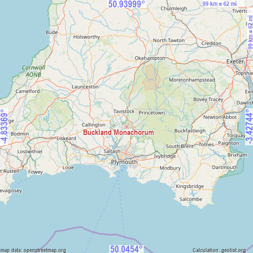
Buckland Monachorum GPS coordinates[2]
50° 29' 41.316" North, 4° 7' 50.016" West
| Map corner | latitude | longitude |
|---|---|---|
| Upper-left | 50.93999°, | -4.83369° |
| Center: | 50.49481°, | -4.13056° |
| Lower-right: | 50.0454°, | -3.42744° |
| Map W x H: | 99.5×99.5 km | = 61.8×61.8mi |
| max Lat: | 60.39635° ⇑98% North |
| Buckland Monachorum: | 50.49481° |
| min Lat: | ⇓2% South 34.60088° |
| min Long | Buckland Monach | max Long |
| -7.64133° | -4.13056° | 32.95536° |
| W 10.3%⇐ | ⇒89.7% E |
Elevation
Elevation of Buckland Monachorum is 95 m = 312 ft, and this is 22.1 m = 73 ft above average elevation for this country.
| Max E: |
515 m = 1690 ft | 30.2% |
| Buckland Monachorum | 95 m 312 ft | |
| Avg. | 72.9 m = 239 ft | |
Min E: |
-30 m = -98 ft | 69.8% |
See also: United Kingdom elevation on elevation.city.
Geographical zone
Buckland Monachorum is located in North temperate zone (between Tropic of Cancer and the Arctic Circle). Distance of this North polar circle is 1786.7 km =1110.2 mi to North.| Distance of | km | miles | from Buckland Monachorum |
|---|---|---|---|
| North Pole | 4392.6 | 2729.4 | to North |
| Arctic Circle | 1786.7 | 1110.2 | to North |
| Tropic Cancer | 3008.6 | 1869.5 | to South |
| Equator | 5614.5 | 3488.7 | to South |


Nearby cities:
15 places around Buckland Monachorum: (largest is in red/bold)
• Bere Alston
4.5 km =2.8 mi,  251°
251°
• Callington
12.9 km =8 mi,  273°
273°
• Calstock
5.4 km =3.4 mi, 271°
• Dousland
4.8 km =3 mi,  82°
82°
• Gunnislake
6.7 km =4.2 mi,  299°
299°
• Horrabridge
2.6 km =1.6 mi,  54°
54°
• Lamerton
9.5 km =5.9 mi,  333°
333°
• Mary Tavy
11.1 km =6.9 mi,  5°
5°
• Pillaton
13 km =8.1 mi, 247°
• Plymouth
13.7 km =8.5 mi,  183°
183°
• Plympton
12.6 km =7.8 mi,  156°
156°
• Princetown
11.4 km =7.1 mi,  61°
61°
• Saltash
11.6 km =7.2 mi,  215°
215°
• Tavistock
6.2 km =3.9 mi,  350°
350°
• Yelverton
3.3 km =2.1 mi,  93°
93°
Sources, notices
• [Note1] Compared only with cities in United Kingdom existing in our database
• [Src1] Map data: © OpenStreetMap contributors (CC-BY-SA)
• [Src2] Other city data from geonames.org with taken over terms of usage.
• [Src3] Geographical zone / Annual Mean Temperature by Robert A. Rohde @ Wikipedia
