Plymouth geodata
Plymouth (England) is a seat of a second-order administrative division; located in United Kingdom in Europe/London (GMT+1) time zone. With population of 260,203 people, there are 27 cities with bigger population in this country. Compared to other cities in United Kingdom, 98.7% of cities are located further ↑North; 89.9% of cities are located further →East and 87% of cities have higher elevation than Plymouth. Note1


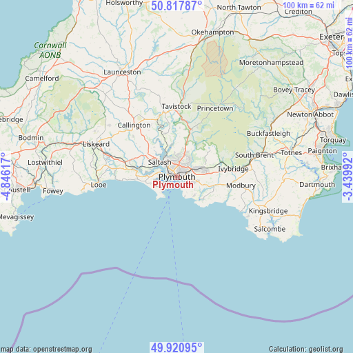
Plymouth GPS coordinates[2]
50° 22' 17.508" North, 4° 8' 34.98" West
| Map corner | latitude | longitude |
|---|---|---|
| Upper-left | 50.81787°, | -4.84617° |
| Center: | 50.37153°, | -4.14305° |
| Lower-right: | 49.92095°, | -3.43992° |
| Map W x H: | 99.7×99.7 km | = 62×62mi |
| max Lat: | 60.39635° ⇑98.7% North |
| Plymouth: | 50.37153° |
| min Lat: | ⇓1.3% South 34.60088° |
| min Long | Plymouth | max Long |
| -7.64133° | -4.14305° | 32.95536° |
| W 10.1%⇐ | ⇒89.9% E |
Elevation
Elevation of Plymouth is 14 m = 46 ft, and this is 58.9 m = 193 ft below average elevation for this country.
| Max E: |
515 m = 1690 ft | 87% |
| Avg. | 72.9 m = 239 ft | |
| Plymouth | 14 m = 46 ft | |
Min E: |
-30 m = -98 ft | 13% |
See also: Plymouth elevation on elevation.city.
Geographical zone
Plymouth is located in North temperate zone (between Tropic of Cancer and the Arctic Circle). Distance of this North polar circle is 1800.4 km =1118.7 mi to North.| Distance of | km | miles | from Plymouth |
|---|---|---|---|
| North Pole | 4406.3 | 2737.9 | to North |
| Arctic Circle | 1800.4 | 1118.7 | to North |
| Tropic Cancer | 2994.9 | 1860.9 | to South |
| Equator | 5600.8 | 3480.2 | to South |


Nearby cities:
15 places around Plymouth: (largest is in red/bold)
• Bere Alston
12.8 km =8 mi,  344°
344°
• Brixton
8.1 km =5 mi,  107°
107°
• Buckland Monachorum
13.7 km =8.5 mi,  3°
3°
• Calstock
14.6 km =9.1 mi, 342°
• Landrake
11.9 km =7.4 mi,  298°
298°
• Millbrook
5.7 km =3.5 mi,  244°
244°
• Newton Ferrers
9.7 km =6 mi,  130°
130°
• Pillaton
14.1 km =8.8 mi,  308°
308°
• Plympton
6.2 km =3.9 mi,  70°
70°
• Plymstock
3.9 km =2.4 mi, 108°
• Saltash
7.2 km =4.5 mi, 306°
• Torpoint
3.8 km =2.4 mi,  275°
275°
• Wembury
7.3 km =4.5 mi,  138°
138°
• Yealmpton
10.5 km =6.5 mi,  104°
104°
• Yelverton
14.1 km =8.8 mi,  17°
17°
Sources, notices
• [Note1] Compared only with cities in United Kingdom existing in our database
• [Src1] Map data: © OpenStreetMap contributors (CC-BY-SA)
• [Src2] Other city data from geonames.org with taken over terms of usage.
• [Src3] Geographical zone / Annual Mean Temperature by Robert A. Rohde @ Wikipedia
