Brighton geodata
Brighton (England) is a seat of a second-order administrative division; located in United Kingdom in Europe/London (GMT+1) time zone. With population of 139,001 people, there are 69 cities with bigger population in this country. Compared to other cities in United Kingdom, 94.7% of cities are located further ↑North; 84.1% of cities are located further ←West and 73.1% of cities have higher elevation than Brighton. Note1


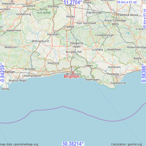
Brighton GPS coordinates[2]
50° 49' 42.168" North, 0° 8' 22.092" West
| Map corner | latitude | longitude |
|---|---|---|
| Upper-left | 51.2704°, | -0.84259° |
| Center: | 50.82838°, | -0.13947° |
| Lower-right: | 50.38214°, | 0.56366° |
| Map W x H: | 98.8×98.8 km | = 61.4×61.4mi |
| max Lat: | 60.39635° ⇑94.7% North |
| Brighton: | 50.82838° |
| min Lat: | ⇓5.3% South 34.60088° |
| min Long | Brighton | max Long |
| -7.64133° | -0.13947° | 32.95536° |
| W 84.1%⇐ | ⇒15.9% E |
Elevation
Elevation of Brighton is 29 m = 95 ft, and this is 43.9 m = 144 ft below average elevation for this country.
| Max E: |
515 m = 1690 ft | 73.1% |
| Avg. | 72.9 m = 239 ft | |
| Brighton | 29 m = 95 ft | |
Min E: |
-30 m = -98 ft | 26.9% |
See also: Brighton elevation on elevation.city.
Geographical zone
Brighton is located in North temperate zone (between Tropic of Cancer and the Arctic Circle). Distance of this North polar circle is 1749.6 km =1087.2 mi to North.| Distance of | km | miles | from Brighton |
|---|---|---|---|
| North Pole | 4355.5 | 2706.4 | to North |
| Arctic Circle | 1749.6 | 1087.2 | to North |
| Tropic Cancer | 3045.7 | 1892.5 | to South |
| Equator | 5651.6 | 3511.7 | to South |


Nearby cities:
15 places around Brighton: (largest is in red/bold)
• Ditchling
10.4 km =6.5 mi,  9°
9°
• Fulking
9.2 km =5.7 mi,  317°
317°
• Hassocks
11.2 km =7 mi,  350°
350°
• Hove
2 km =1.2 mi,  278°
278°
• Hurstpierpoint
12.1 km =7.5 mi, 346°
• Kingston near Lewes
8.9 km =5.5 mi,  68°
68°
• Lancing
12.9 km =8 mi,  270°
270°
• Lewes
11.6 km =7.2 mi,  64°
64°
• Peacehaven
10.1 km =6.3 mi,  113°
113°
• Plumpton Green
13 km =8.1 mi,  25°
25°
• Portslade
5.6 km =3.5 mi,  286°
286°
• Rodmell
11 km =6.8 mi,  83°
83°
• Rottingdean
6 km =3.7 mi, 110°
• Shoreham-by-Sea
9.5 km =5.9 mi, 273°
• Small Dole
12.6 km =7.8 mi,  309°
309°
Sources, notices
• [Note1] Compared only with cities in United Kingdom existing in our database
• [Src1] Map data: © OpenStreetMap contributors (CC-BY-SA)
• [Src2] Other city data from geonames.org with taken over terms of usage.
• [Src3] Geographical zone / Annual Mean Temperature by Robert A. Rohde @ Wikipedia
