Brentwood geodata
Brentwood (England) is a populated place; located in United Kingdom in Europe/London (GMT+1) time zone. With population of 52,586 people, there are 218 cities with bigger population in this country. Compared to other cities in United Kingdom, 73.6% of cities are located further ↑North; 90.4% of cities are located further ←West and 75.7% of cities have lower elevation than Brentwood. Note1


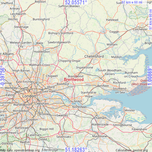
Brentwood GPS coordinates[2]
51° 37' 16.572" North, 0° 18' 20.016" East
| Map corner | latitude | longitude |
|---|---|---|
| Upper-left | 52.05571°, | -0.39756° |
| Center: | 51.62127°, | 0.30556° |
| Lower-right: | 51.18263°, | 1.00869° |
| Map W x H: | 97.1×97.1 km | = 60.3×60.3mi |
| max Lat: | 60.39635° ⇑73.6% North |
| Brentwood: | 51.62127° |
| min Lat: | ⇓26.4% South 34.60088° |
| min Long | Brentwood | max Long |
| -7.64133° | 0.30556° | 32.95536° |
| W 90.4%⇐ | ⇒9.6% E |
Elevation
Elevation of Brentwood is 108 m = 354 ft, and this is 35.1 m = 115 ft above average elevation for this country.
| Max E: |
515 m = 1690 ft | 24.3% |
| Brentwood | 108 m 354 ft | |
| Avg. | 72.9 m = 239 ft | |
Min E: |
-30 m = -98 ft | 75.7% |
See also: Brentwood elevation on elevation.city.
Geographical zone
Brentwood is located in North temperate zone (between Tropic of Cancer and the Arctic Circle). Distance of this North polar circle is 1661.4 km =1032.3 mi to North.| Distance of | km | miles | from Brentwood |
|---|---|---|---|
| North Pole | 4267.3 | 2651.6 | to North |
| Arctic Circle | 1661.4 | 1032.3 | to North |
| Tropic Cancer | 3133.8 | 1947.3 | to South |
| Equator | 5739.7 | 3566.5 | to South |


Nearby cities:
15 places around Brentwood: (largest is in red/bold)
• Billericay
7.9 km =4.9 mi,  84°
84°
• Blackmore
8 km =5 mi,  6°
6°
• Bulphan
9.2 km =5.7 mi,  155°
155°
• Chipping Ongar
10.1 km =6.3 mi,  335°
335°
• Collier Row
10 km =6.2 mi,  255°
255°
• Cranham
6.8 km =4.2 mi,  203°
203°
• Harold Wood
5.8 km =3.6 mi,  239°
239°
• High Ongar
10.3 km =6.4 mi, 343°
• Hornchurch
9.4 km =5.8 mi,  220°
220°
• Ingatestone
7.7 km =4.8 mi,  44°
44°
• Ingrave
3.1 km =1.9 mi,  128°
128°
• Kelvedon Hatch
5.7 km =3.5 mi,  333°
333°
• Romford
9.7 km =6 mi, 238°
• Stock
10.6 km =6.6 mi,  63°
63°
• Upminster
8 km =5 mi,  205°
205°
Sources, notices
• [Note1] Compared only with cities in United Kingdom existing in our database
• [Src1] Map data: © OpenStreetMap contributors (CC-BY-SA)
• [Src2] Other city data from geonames.org with taken over terms of usage.
• [Src3] Geographical zone / Annual Mean Temperature by Robert A. Rohde @ Wikipedia
