Braintree geodata
Braintree (England) is a populated place; located in United Kingdom in Europe/London (GMT+1) time zone. With population of 53,477 people, there are 216 cities with bigger population in this country. Compared to other cities in United Kingdom, 65.6% of cities are located further ↑North; 92.9% of cities are located further ←West and 54.7% of cities have lower elevation than Braintree. Note1


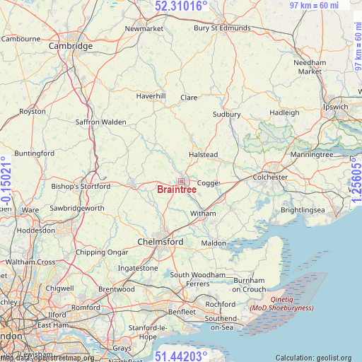
Braintree GPS coordinates[2]
51° 52' 41.484" North, 0° 33' 10.512" East
| Map corner | latitude | longitude |
|---|---|---|
| Upper-left | 52.31016°, | -0.15021° |
| Center: | 51.87819°, | 0.55292° |
| Lower-right: | 51.44203°, | 1.25605° |
| Map W x H: | 96.5×96.5 km | = 60×60mi |
| max Lat: | 60.39635° ⇑65.6% North |
| Braintree: | 51.87819° |
| min Lat: | ⇓34.4% South 34.60088° |
| min Long | Braintree | max Long |
| -7.64133° | 0.55292° | 32.95536° |
| W 92.9%⇐ | ⇒7.1% E |
Elevation
Elevation of Braintree is 68 m = 223 ft, and this is 4.9 m = 16 ft below average elevation for this country.
| Max E: |
515 m = 1690 ft | 45.3% |
| Avg. | 72.9 m = 239 ft | |
| Braintree | 68 m = 223 ft | |
Min E: |
-30 m = -98 ft | 54.7% |
See also: Braintree elevation on elevation.city.
Geographical zone
Braintree is located in North temperate zone (between Tropic of Cancer and the Arctic Circle). Distance of this North polar circle is 1632.9 km =1014.6 mi to North.| Distance of | km | miles | from Braintree |
|---|---|---|---|
| North Pole | 4238.7 | 2633.8 | to North |
| Arctic Circle | 1632.9 | 1014.6 | to North |
| Tropic Cancer | 3162.4 | 1965 | to South |
| Equator | 5768.3 | 3584.3 | to South |


Nearby cities:
15 places around Braintree: (largest is in red/bold)
• Black Notley
3 km =1.9 mi,  159°
159°
• Coggeshall
9.1 km =5.7 mi,  95°
95°
• Ford End
10.2 km =6.3 mi,  234°
234°
• Gosfield
7 km =4.3 mi,  22°
22°
• Great Bardfield
11.1 km =6.9 mi,  314°
314°
• Great Leighs
6.5 km =4 mi,  209°
209°
• Halstead
9.5 km =5.9 mi,  38°
38°
• Kelvedon
11.3 km =7 mi,  111°
111°
• Little Dunmow
9.7 km =6 mi,  258°
258°
• Panfield
3.1 km =1.9 mi,  316°
316°
• Rayne
2.4 km =1.5 mi,  121°
121°
• Silver End
6 km =3.7 mi,  125°
125°
• Stebbing
9.6 km =6 mi,  278°
278°
• Wethersfield
9.5 km =5.9 mi,  332°
332°
• Witham
10.6 km =6.6 mi,  145°
145°
Sources, notices
• [Note1] Compared only with cities in United Kingdom existing in our database
• [Src1] Map data: © OpenStreetMap contributors (CC-BY-SA)
• [Src2] Other city data from geonames.org with taken over terms of usage.
• [Src3] Geographical zone / Annual Mean Temperature by Robert A. Rohde @ Wikipedia
